Data
- Obtaining
- Supplying
- High-Frequency
- Bottom Pressure Records
- Other Long Records
- GLOSS/ODINAFRICA Calibration Data
Donate
Donate to PSMSL
Data Notes
- Individual Station Data and Plot Notes
- Referencing the Data Set
- PSMSL Help File
- 2010 Changes to the PSMSL Data Files
Extracted from Database
20 Jul 2026
Station Information
| Station ID: | 1112 |
| Latitude: | 57.89525 |
| Longitude: | -5.157889 |
| Coastline code: | 170 |
| Station code: | 249 |
| Country: | UNITED KINGDOM |
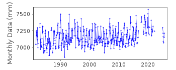
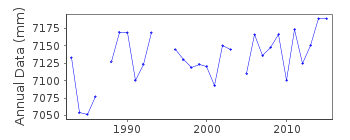
| Time span of RLR data: | 1981 – 2025 |
| RLR completeness (%): | 81 |
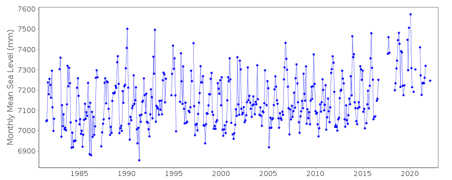
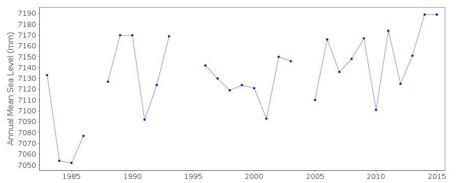
| Time span of metric data: | 1965 – 2025 |
| Metric completeness (%): | 76 |
| MTL Data: | 1965 |
| MTL-MSL (mm): | -73 |
| Date of last update: | 19 Feb 2026 |
| Green Arrow: | Current Station |
| Yellow Marker: | Neighbouring RLR Station |
| Red Marker: | Neighbouring Metric Station |
Please note: In many cases, the station position in our database is accurate to only one minute. Thus, the tide gauge may not appear to be on the coast.
Tide Gauge Data
Additional Data Sources (guide to additional data sources)
Nearby GNSS Stations from SONEL: ULLO, ULLP, ULLANearby Real Time Stations from VLIZ: ulla
Station Documentation
Link to RLR information.Documentation - date unknown
Ullapool 1978 charts badly trimmed , data unreliable1979 Sept-Oct results suspect 1980 very bad damp and badly maintained. 1965 values based on high and low waters.Documentation added 1991-06-11
Ullapool 170/249 RLR(1984) is 11.2m below TGBM NH1288 9391Documentation added 1994-07-20
A Lea stilling well gauge was installed in April 1963, replaced by a Munro in the same well in 1981. Since May 1987 the gauge has been an "A Class" bubbler system.Documentation added 2001-01-02
Recent work on vertical land movements in the UK can be found from the University of Nottingham web site: http://ukcogr.iessg.nottingham.ac.uk/~eosi/Documentation added 2014-07-04
During 2013 TGI visited the Ullapool site twice. 27.03.2013 for general maintenance and 17.07.2013 again for general maintenance, to change the compressor and and seal leaks in the hut roof joint.Documentation added 2015-06-02
There was an electrical fault at site from the end of September through to November.TGI were at site 3.10.14 for General maintenance,change the compressor and to rectify water/damp damage and refurbishment.Documentation added 2016-01-22
A value of MTL-MSL=-73 mm has been derived using the GESLA2 (high-frequency tide gauge) dataset using harmonic constituents. As the correction is only applied to RLR data and the data from 1965 is metric, it is not used in the data set. Should this period become metric in future, however, it would be used. The 001 flag has been set only because this correction is highly uncertain.Data Authority
Environment AgencyHorizon House
Deanery Road
BS1 5AH
Bristol

![]()
![]()
![]()
