Data
- Obtaining
- Supplying
- High-Frequency
- Bottom Pressure Records
- Other Long Records
- GLOSS/ODINAFRICA Calibration Data
Donate
Donate to PSMSL
Data Notes
- Individual Station Data and Plot Notes
- Referencing the Data Set
- PSMSL Help File
- 2010 Changes to the PSMSL Data Files
Extracted from Database
13 Jul 2026
Station Information
| Station ID: | 1110 |
| Latitude: | 82.49 |
| Longitude: | -62.32 |
| GLOSS ID: | 333 |
| Coastline code: | 970 |
| Station code: | 162 |
| Country: | CANADA |
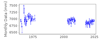
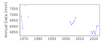
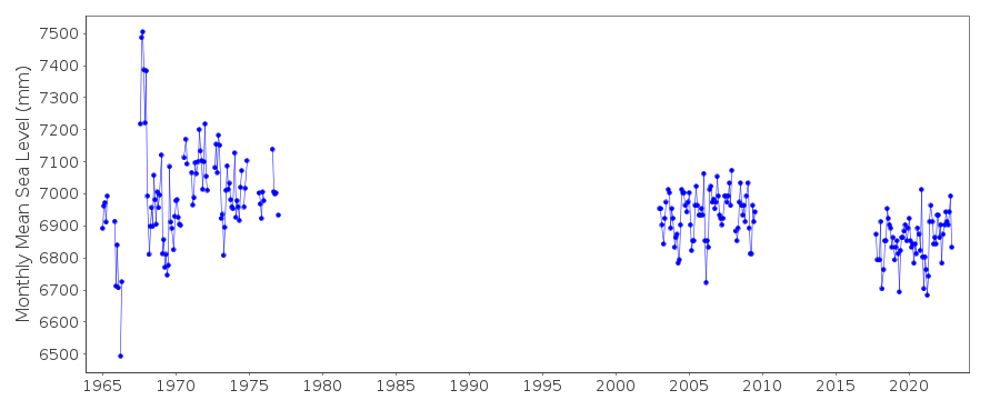
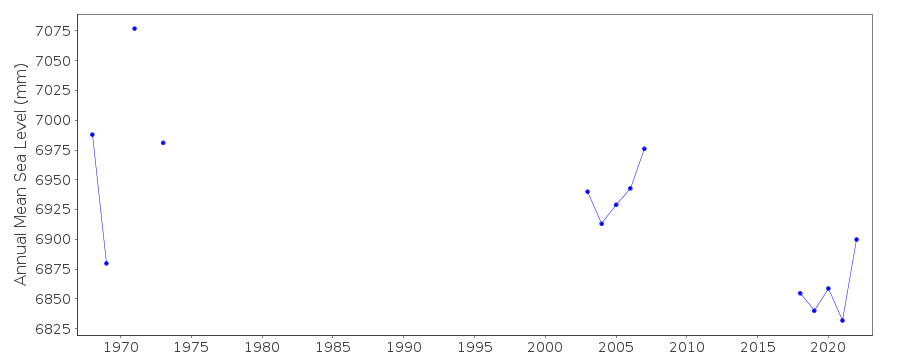
| Time span of data: | 1965 – 2024 |
| Completeness (%): | 36 |
| Link to ellipsoid: | Available |
| Date of last update: | 19 Jun 2025 |
| Green Arrow: | Current Station |
| Yellow Marker: | Neighbouring RLR Station |
| Red Marker: | Neighbouring Metric Station |
Please note: In many cases, the station position in our database is accurate to only one minute. Thus, the tide gauge may not appear to be on the coast.
Tide Gauge Data
Additional Data Sources (guide to additional data sources)
Nearby GNSS Stations from SONEL: ALRTNearby Real Time Stations from VLIZ: aler
Fast Delivery Data from UHSLC station 836: hourly and daily
Station Documentation
Link to RLR information.Documentation added 1991-06-11
Alert 970/162 RLR(1968) is 9.6m below BM-3-1960Documentation added 2009-01-28
Treat data 1965-1968 as suspect.Documentation added 2010-08-04
Tide gauge at Alert was re-instated in January 2003. Same benchmark still used - data collated from the Fisheries and Oceans Canada webpage.Documentation added 2019-06-18
Arctic station Alert has been reporting regularly.Data Authority
Canadian Hydrographic Service615 Booth Street
Ottawa
Ontario K1A 0E6

![]()
![]()
![]()
