Data
- Obtaining
- Supplying
- High-Frequency
- Bottom Pressure Records
- Other Long Records
- GLOSS/ODINAFRICA Calibration Data
Donate
Donate to PSMSL
Data Notes
- Individual Station Data and Plot Notes
- Referencing the Data Set
- PSMSL Help File
- 2010 Changes to the PSMSL Data Files
Extracted from Database
13 Jul 2026
Station Information
| Station ID: | 1082 |
| Latitude: | -51.690339 |
| Longitude: | -57.864931 |
| GLOSS ID: | 305 |
| Coastline code: | 863 |
| Station code: | 1 |
| Country: | FALKLAND ISLANDS (MALVINAS) |
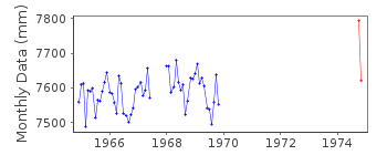
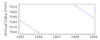
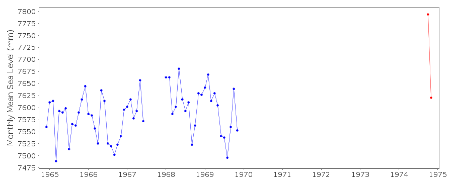
| Time span of data: | 1964 – 1974 |
| Completeness (%): | 42 |
| Date of last update: | 01 Jan 1980 |
| Green Arrow: | Current Station |
| Yellow Marker: | Neighbouring RLR Station |
| Red Marker: | Neighbouring Metric Station |
Please note: In many cases, the station position in our database is accurate to only one minute. Thus, the tide gauge may not appear to be on the coast.
Tide Gauge Data
Additional Data Sources (guide to additional data sources)
Nearby Real Time Stations from VLIZ: stan2Fast Delivery Data from UHSLC station 290: hourly and daily
Research Quality Data from UHSLC station 290: hourly and daily
Station Documentation
Link to RLR information.Documentation added 1999-11-22
The Port Stanley float gauge (Lea company) was installed inNovember 1964 as an arrangement between Fuchs and Irving around 1963.
It was run by the Colonial Office to about 1975 but the quality of
the records from 1970 is said to be poor. It was located inside the
conference room at the west end of the Government Jetty in Stanley
Harbour and still existed in some condition up to 1982. The tide
gauge zero was Chart Datum which was 20.53 feet below the BM on
the PWD Office.
Documentation added 1999-12-06
The RLR datums for both Stanley I (863/001) and Stanley II (863/002)have been set to be 10.7 m below benchmark A which is the same as 12.83 m below
the PWD Office BM. The two RLR series can be combined if required
although there is a large passage of time between them.
Documentation added 2005-09-20
Sea level changes at Port Stanley are discussed byWoodworth, P.L., Pugh, D.T., Meredith, M.P. and Blackman, D.L. 2005.
Sea level changes at Port Stanley, Falkland Islands. Journal
of Geophysical Research, Vol. 110, C06013, doi:10.1029/2004JC002648.
Data Authority
United Kingdom Hydrographic OfficeAdmiralty Way
Taunton
Somerset
TA1 2DN

![]()
![]()
![]()
