Data
- Obtaining
- Supplying
- High-Frequency
- Bottom Pressure Records
- Other Long Records
- GLOSS/ODINAFRICA Calibration Data
Donate
Donate to PSMSL
Data Notes
- Individual Station Data and Plot Notes
- Referencing the Data Set
- PSMSL Help File
- 2010 Changes to the PSMSL Data Files
Extracted from Database
20 Jul 2026
Station Information
| Station ID: | 1074 |
| Latitude: | 56.016667 |
| Longitude: | -3.45 |
| Coastline code: | 170 |
| Station code: | 27 |
| Country: | UNITED KINGDOM |
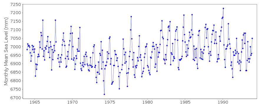
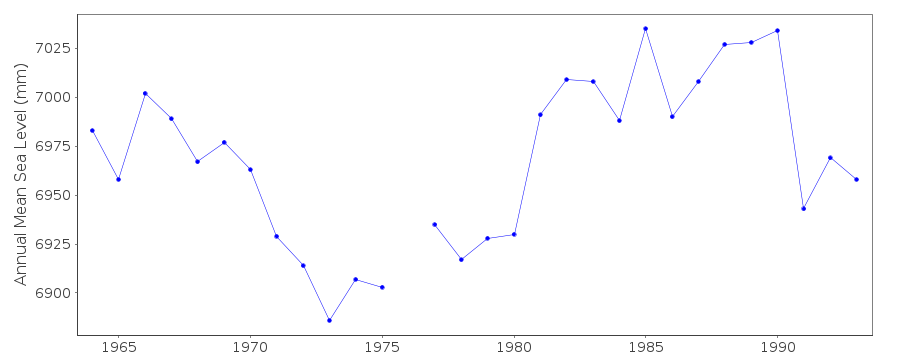
| Time span of data: | 1964 – 1993 |
| Completeness (%): | 99 |
| Date of last update: | 29 Mar 1994 |
| Green Arrow: | Current Station |
| Yellow Marker: | Neighbouring RLR Station |
| Red Marker: | Neighbouring Metric Station |
Please note: In many cases, the station position in our database is accurate to only one minute. Thus, the tide gauge may not appear to be on the coast.
Tide Gauge Data
Station Documentation
Link to RLR information.Documentation added 1991-06-11
Rosyth 170/027 RLR(1964) is 11.4m below TGBM NT1000 8171Documentation added 1993-07-12
Rosyth 170/027 RLR(1964) is 11.4m below TGBM NT1000 8171Documentation added 1994-09-16
Cary Porter gauge (stilling well) installed August 1955.Data reduced by Hydrographic Department
Documentation added 2001-01-02
Recent work on vertical land movements in the UK can be found fromthe University of Nottingham web site:
http://ukcogr.iessg.nottingham.ac.uk/~eosi/
Documentation added 2002-01-09
Rosyth gauge ceased operating October 1995.Data Authority
United Kingdom Hydrographic OfficeAdmiralty Way
Taunton
Somerset
TA1 2DN

![]()
![]()
![]()
