Data
- Obtaining
- Supplying
- High-Frequency
- Bottom Pressure Records
- Other Long Records
- GLOSS/ODINAFRICA Calibration Data
Donate
Donate to PSMSL
Data Notes
- Individual Station Data and Plot Notes
- Referencing the Data Set
- PSMSL Help File
- 2010 Changes to the PSMSL Data Files
Extracted from Database
13 Jul 2026
Station Information
| Station ID: | 1037 |
| Latitude: | 53.5575 |
| Longitude: | 6.747778 |
| Coastline code: | 140 |
| Station code: | 16 |
| Country: | GERMANY |
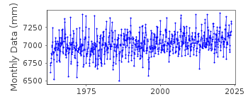
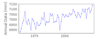
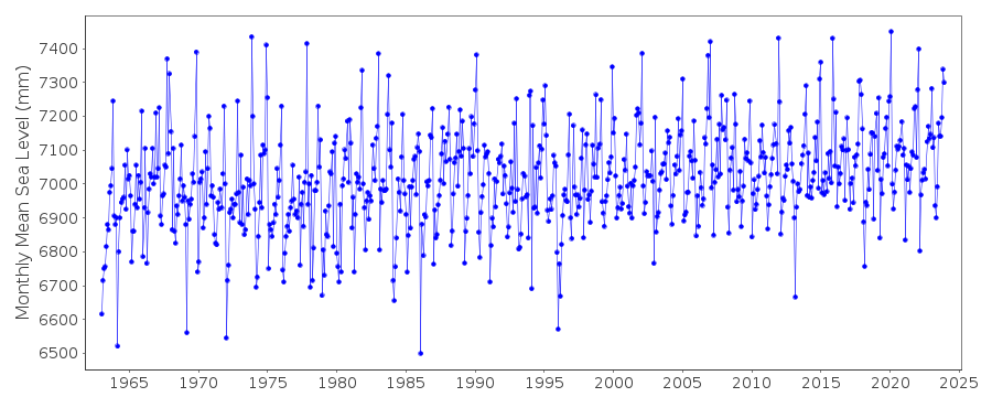
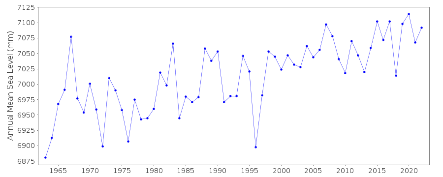
| Time span of data: | 1963 – 2025 |
| Completeness (%): | 100 |
| Link to ellipsoid: | Available |
| Date of last update: | 02 Jul 2026 |
| Green Arrow: | Current Station |
| Yellow Marker: | Neighbouring RLR Station |
| Red Marker: | Neighbouring Metric Station |
Please note: In many cases, the station position in our database is accurate to only one minute. Thus, the tide gauge may not appear to be on the coast.
Tide Gauge Data
Additional Data Sources (guide to additional data sources)
Nearby GNSS Stations from SONEL: BORK, TGBF, BORJ, TGBSNearby Real Time Stations from VLIZ: bork
Station Documentation
Link to RLR information.Documentation added 2001-04-09
Data for 2000 supplied to TGZ, previously to "Normal Null".Documentation added 2001-04-11
Data up to 1984 were high and low waters (mean tide level). MSL thereafter.Documentation added 2001-06-25
Borkum - data 1963-99 apparently corrected to NN (Normal Null).Documentation added 2008-01-23
RLR value for Borkum for 2003 and 2004 adjusted from 1.980 to 1.970 following email and attached TGZ information dated 2.11.2007 from Sylvin Mueller Navarra.Documentation added 2010-08-09
The data used to be measured to Normal Null which is a German datum related to levels at Potsdam near Berlin. It is similar to ODN in the UK or NAP in Holland. It is ususual therefore that the station was made RLR as it 'breaks the rules' of RLR. Data 2000 onwards refers to TGZ.Documentation added 2016-01-26
A value of MTL-MSL=-81 mm has been applied to the RLR data for the period 1963-1984. This value was derived by Thomas Wahl, using the "k factor method" described in Wahl et al., 61, 701-715, 2011.Documentation added 2016-08-30
Using values from the BSH website the latitude and longitude for this stations have been updated.Documentation added 2017-11-15
Data for 2011 onwards has been supplied using RLR as the datum. Therefore no adjustment needs to be applied to the data.Documentation added 2019-09-11
The complete dataset for this station has been supplied by the Federal Waterways and Shipping Administration, provided by the Federal Institute of Hydrology.Data Authority
Bundesamt fur Seeschifffahrt und Hydrographie HamburgBernhard-Nocht-Strasse 78
20359 Hamburg
Documentation added 1993-10-05
FORMERLY THE DEUTSCHES HYDROGRAPHISCHES INSTITUT

![]()
![]()
![]()
