Data
- Obtaining
- Supplying
- High-Frequency
- Bottom Pressure Records
- Other Long Records
- GLOSS/ODINAFRICA Calibration Data
Donate
Donate to PSMSL
Data Notes
- Individual Station Data and Plot Notes
- Referencing the Data Set
- PSMSL Help File
- 2010 Changes to the PSMSL Data Files
Extracted from Database
20 Jul 2026
Station Information
| Station ID: | 1030 |
| Latitude: | 32.644 |
| Longitude: | -16.913067 |
| GLOSS ID: | 250 |
| Coastline code: | 365 |
| Station code: | 1 |
| Country: | PORTUGAL |
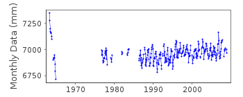
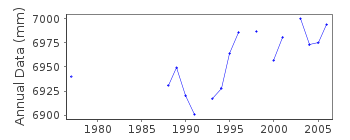
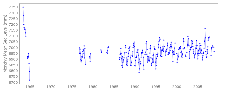
| Time span of data: | 1963 – 2008 |
| Completeness (%): | 54 |
| Date of last update: | 14 Apr 2009 |
| Green Arrow: | Current Station |
| Yellow Marker: | Neighbouring RLR Station |
| Red Marker: | Neighbouring Metric Station |
Please note: In many cases, the station position in our database is accurate to only one minute. Thus, the tide gauge may not appear to be on the coast.
Tide Gauge Data
Additional Data Sources (guide to additional data sources)
Nearby GNSS Stations from SONEL: FUNCFast Delivery Data from UHSLC station 218: hourly and daily
Research Quality Data from UHSLC station 218: hourly and daily
Station Documentation
Link to RLR information.Documentation added 1991-06-11
Funchal 365/001 RLR(1977) is 9.7m below TGBMDocumentation added 1993-07-12
Funchal 365/001 RLR(1977) is 9.7m below TGBMDocumentation added 1993-07-12
Erratic data during 1963-64.Documentation added 1994-05-23
1990-91 DATA RECEIVED FROM TOGA OFFICEDocumentation added 1998-11-04
data for 1990-93 replaced with revised values received from authority 41Documentation added 2006-10-25
Full dataset 1962-2005 has been updated using revised values assupplied by the Portugese Hydrographic Institute in their 2004/5
report.RLR has been recalculated using RLR year 2005.
RLR factor is 5.382m and RLR (2005) is 9.6m below TGBM MHIA 1936
Documentation added 2009-01-28
Treat data 1963-1965 as suspect.Documentation added 2010-05-20
Due to harbour contruction works this tide gauge at Funchal is giving badquality data and will soon be defunct. A replacement gauge has been in
operation since the end of 2003. This has been named Funchal II
Data Authority
Hydrographic InstituteRua das Trinas 49
1249-093 Lisboa

![]()
![]()
![]()
