Data
- Obtaining
- Supplying
- High-Frequency
- Bottom Pressure Records
- Other Long Records
- GLOSS/ODINAFRICA Calibration Data
Donate
Donate to PSMSL
Data Notes
- Individual Station Data and Plot Notes
- Referencing the Data Set
- PSMSL Help File
- 2010 Changes to the PSMSL Data Files
Extracted from Database
13 Jul 2026
Station Information
| Station ID: | 1009 |
| Latitude: | 45.54811 |
| Longitude: | 13.72455 |
| Coastline code: | 279 |
| Station code: | 2 |
| Country: | SLOVENIA |
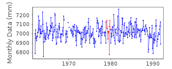
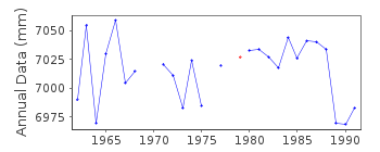
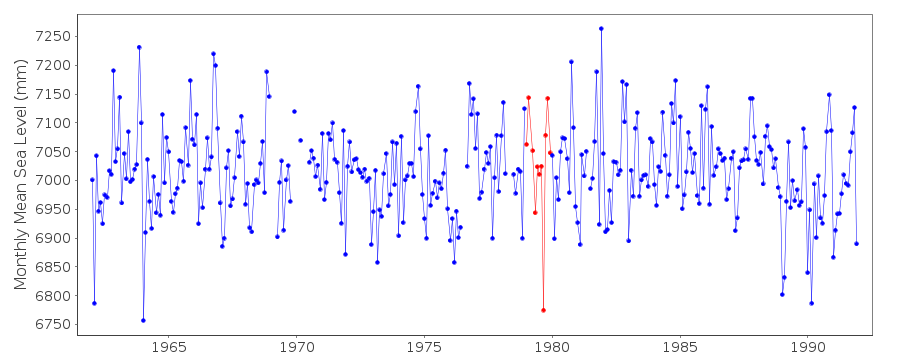
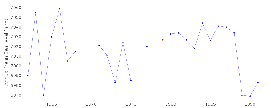
| Time span of data: | 1962 – 1991 |
| Completeness (%): | 96 |
| Link to ellipsoid: | Available |
| Date of last update: | 18 Dec 1997 |
| Green Arrow: | Current Station |
| Yellow Marker: | Neighbouring RLR Station |
| Red Marker: | Neighbouring Metric Station |
Please note: In many cases, the station position in our database is accurate to only one minute. Thus, the tide gauge may not appear to be on the coast.
Tide Gauge Data
Station Documentation
Link to RLR information.Documentation added 1992-11-30
KOPER 279/002 RLR(1964) IS 8.9 M BELOW BM 5486Documentation added 1993-09-13
1991 NEW INSTRUMENT INSTALLEDDocumentation added 1994-07-14
Anomalously low value for September 1979 correct as received fromauthority.
Documentation added 1996-01-12
Tide gauge of the Hydrometeorological Institute of theRepublic of Slovenia
Documentation added 1996-01-12
Gauge=Matra (KOVO, Praha) until May 1978 when substituted by newsystem= Seba-Bandschreiberpegel Delta (Seba Hydrometrie, Germany)
Documentation added 1996-01-12
data up to 1964 supplied by auth 25Documentation added 1996-01-12
PRIOR TO 1990 DATA FROM AUTH 26Documentation added 1997-12-18
data for 1990 received from authority code E1Documentation added 1998-01-28
data for 1992 onwards from new gauge; data up to 1991 from gauge at45 33 N 13 44 E
Documentation added 1998-04-28
Data for 1992 onwards is from gauge at Luka Koper, see station 279/003Koper is an historic station last data 1991
Data Authority
Hydrometeorological Institute of SloveniaVojkova 1b
1001 Ljubljana, P.P. 2549

![]()
![]()
![]()
