Data
- Obtaining
- Supplying
- High-Frequency
- Bottom Pressure Records
- Other Long Records
- GLOSS/ODINAFRICA Calibration Data
Donate
Donate to PSMSL
Data Notes
- Individual Station Data and Plot Notes
- Referencing the Data Set
- PSMSL Help File
- 2010 Changes to the PSMSL Data Files
Extracted from Database
13 Jul 2026
Station Information
| Station ID: | 1 |
| Latitude: | 48.38285 |
| Longitude: | -4.494838 |
| GLOSS ID: | 242 |
| Coastline code: | 190 |
| Station code: | 91 |
| Country: | FRANCE |
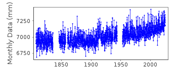
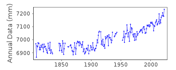
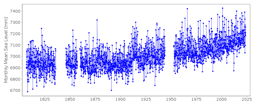
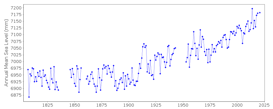
| Time span of data: | 1807 – 2025 |
| Completeness (%): | 88 |
| MTL Data: | 1807-1835 |
| MTL-MSL (mm): | -23 |
| Link to ellipsoid: | Available |
| Date of last update: | 20 Feb 2026 |
| Green Arrow: | Current Station |
| Yellow Marker: | Neighbouring RLR Station |
| Red Marker: | Neighbouring Metric Station |
Please note: In many cases, the station position in our database is accurate to only one minute. Thus, the tide gauge may not appear to be on the coast.
Tide Gauge Data
Additional Data Sources (guide to additional data sources)
Nearby GNSS Stations from SONEL: GUIP, BGBC, BRSTNearby Real Time Stations from VLIZ: bres
Fast Delivery Data from UHSLC station 822: hourly and daily
Research Quality Data from UHSLC station 822: hourly and daily
Station Documentation
Link to RLR information.Documentation added 1993-07-12
Brest 190/091 RLR(1964) is 12.5m below NGF no1Documentation added 2007-01-21
Older data from Brest are taken from the original volumes of the Publications Scientifiques. In those, 1807-35 are said to be Mean Tide Level and 1846 onwards true Mean Sea Level. At Brest MSL is 23mm above MTL (some estimates say 29 mm), see Woppelmann et al. Ocean Dynamics, 56, 487-497, 2006 (and beware that the equation top of page 495 should read MTL-MSL). (NOTE: 23 and 29 mm values switched to better reflect paper. 26-Jan-2016)Documentation added 2009-07-21
All monthly means 1937, 1939-1943 replaced and small corrections made to 1917 following the work of Nicolas Pouvreau of the University of La Rochelle.Documentation added 2014-08-28
After investigation the RLR diagram has been revised. Primary benchmark remains the same but the name has been changed to agree with SONEL. Benchmark name is now NO-47. The RLR factor has also been changed when a 2mm discrepancy was found from the original diagram. RLR factor for 1996 onwards is now 2.959.Documentation added 2014-09-24
Using values from the SONEL website the latitude and longitude values have been revised. Additional data for 1857-1860 were included in the SONEL data this has now been added to the database.Documentation added 2016-01-26
A value of MTL-MSL=-23 mm has been applied to the RLR data for the period 1807-1835. This value was taken from the Wöppelmann et al. reference above.Documentation added 2025-07-15
Updated the whole dataset to ensure they include all the historical data recovered recently by SHOM and the calculated monthly and annual means match those distributed by SONEL.Data Authority
SHOM13 rue de Chatelier
29200 BREST

![]()
![]()
![]()
