Data
- Obtaining
- Supplying
- High-Frequency
- Bottom Pressure Records
- Other Long Records
- GLOSS/ODINAFRICA Calibration Data
Donate
Donate to PSMSL
Data Notes
- Individual Station Data and Plot Notes
- Referencing the Data Set
- PSMSL Help File
- 2010 Changes to the PSMSL Data Files
Extracted from Database
11 Mar 2024
Station Information
| Station ID: | 983 |
| Latitude: | -12.116694 |
| Longitude: | 96.894417 |
| GLOSS ID: | 46 |
| Coastline code: | 680 |
| Station code: | 521 |
| Country: | COCOS (KEELING) ISLANDS |
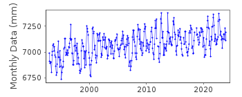
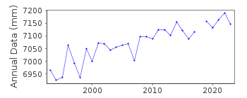
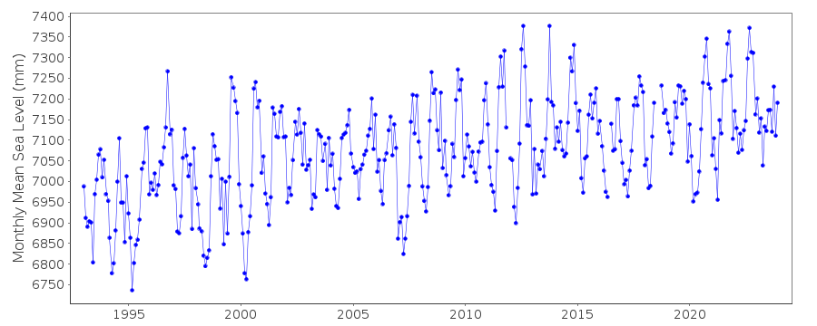
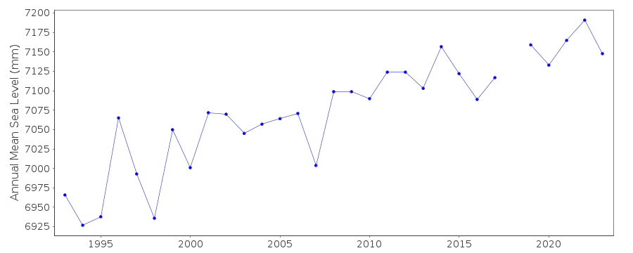
| Time span of RLR data: | 1993 – 2023 |
| RLR completeness (%): | 99 |
| Time span of metric data: | 1961 – 2023 |
| Metric completeness (%): | 60 |
| Date of last update: | 01 Feb 2024 |
| Green Arrow: | Current Station |
| Yellow Marker: | Neighbouring RLR Station |
| Red Marker: | Neighbouring Metric Station |
Please note: In many cases, the station position in our database is accurate to only one minute. Thus, the tide gauge may not appear to be on the coast.
Tide Gauge Data
Additional Data Sources (guide to additional data sources)
Nearby GNSS Stations from SONEL: COCONearby Real Time Stations from VLIZ: cocb
Fast Delivery Data from UHSLC station 171: hourly and daily
Research Quality Data from UHSLC station 171: hourly and daily
Station Documentation
Link to RLR information.Documentation added 1991-11-13
Data for 1969 was supplied by the National Tidal Centre, Bureau of Meteorology, South Australia based on hourly valuesDocumentation added 1995-05-02
Station density along some sections of the Australian coast has meant that station codes 601 onwards have been re-ordered compared to those in earlier versions of the PSMSL data set.Data for 1961-1962 was supplied by Australian Ocean Data Centre N.S.W.These data are based on High and Low water readings.
Documentation added 1996-03-28
Revised data for 1985-1990 was supplied by the National Tidal Centre, Bureau of Meteorology, South Australia. SEAFRAME station installed 04/09/92. Cocos (Keeling) Is. is a cooperative station between NTF and NOAA/NOSDocumentation added 1998-01-20
1985-1992: gauge type=Float/well system Stevens analog-to-digital recorderDocumentation added 1998-01-21
1961-65: float/stilling well gauge located on original jetty West Is. 1968-71 float/stilling well gauge located near jetty, West Is.Documentation added 2000-04-10
This is a "baseline station" of the Australian National Tidal Facility.Documentation added 2000-04-10
Cocos Is.(Home Is.) 680/521 RLR(1996) is 8.604 below PSM101Documentation added 2011-10-27
Using metadata from the National Tidal Centre, Australia the RLR diagram has been revised. Primary benchmark is SEAFRAME sensor benchmark 3.554m above Tide Gauge Zero (TGZ). RLR factor is 6.20m.Documentation added 2019-01-23
Data values for March, May, July, August and September 2016 have been revised.Data Authority
National Tidal CentreBureau of Meteorology
PO Box 421
Kent Town 5071
South Australia
Documentation added 2010-08-12
Formerly known as the National Tidal Facility

![]()
![]()
![]()
