Data
- Obtaining
- Supplying
- High-Frequency
- Bottom Pressure Records
- Other Long Records
- GLOSS/ODINAFRICA Calibration Data
Donate
Donate to PSMSL
Data Notes
- Individual Station Data and Plot Notes
- Referencing the Data Set
- PSMSL Help File
- 2010 Changes to the PSMSL Data Files
Extracted from Database
11 Mar 2024
Station Information
| Station ID: | 819 |
| Latitude: | -38.033333 |
| Longitude: | -57.516667 |
| GLOSS ID: | 192 |
| Coastline code: | 860 |
| Station code: | 101 |
| Country: | ARGENTINA |
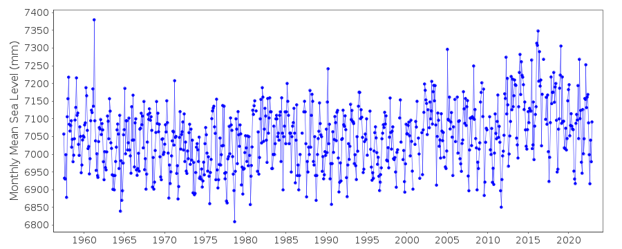
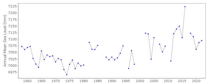
| Time span of data: | 1957 – 2022 |
| Completeness (%): | 95 |
| Date of last update: | 01 Feb 2023 |
| Green Arrow: | Current Station |
| Yellow Marker: | Neighbouring RLR Station |
| Red Marker: | Neighbouring Metric Station |
Please note: In many cases, the station position in our database is accurate to only one minute. Thus, the tide gauge may not appear to be on the coast.
Tide Gauge Data
Additional Data Sources (guide to additional data sources)
Nearby GNSS Stations from SONEL: MPLA, MPL2Nearby Real Time Stations from VLIZ: plat2
Fast Delivery Data from UHSLC station 729: hourly and daily
Research Quality Data from UHSLC station 729: hourly and daily
Station Documentation
Link to RLR information.Documentation - date unknown
NOTICEABLE METEOROLOGICAL INFLUENCESDocumentation added 1991-06-11
Mar del Plata(Club) 860/101 RLR(1977) is 11.8m below Repere No 11Documentation added 1993-07-12
Mar del Plata(Club) 860/101 RLR(1977) is 11.8m below Repere No 11Documentation added 1999-08-20
station is equipped with both float gauge and NGWLMS systemDocumentation added 2001-03-21
Acoustic gauge installed 1992, alongside existing float gauge.Mid 1998 - tide gauge found to be left dry after dredging works.
May 1999 gauge relocated 5km south, within Naval Base.
Documentation added 2002-01-09
Mar del Plata (Club) gauge (38 03 S, 57 33W) moved toMar del Plata (Naval Base) (38 02'S, 57 31'W) December
1998 because of beach works. New site levelled into
old benchmark (Repere No.11) and data treated as continuous.
Documentation added 2023-02-01
Mar del Plata (Base Naval) station was moved back to Mar del Plata (Club) tide gauge.Data Authority
Servicio de Hidrografia NavalDepartmento Oceanografia
Av. Montes de Oca 2124
1271 Buenos Aires

![]()
![]()
![]()
