Data
- Obtaining
- Supplying
- High-Frequency
- Bottom Pressure Records
- Other Long Records
- GLOSS/ODINAFRICA Calibration Data
Donate
Donate to PSMSL
Data Notes
- Individual Station Data and Plot Notes
- Referencing the Data Set
- PSMSL Help File
- 2010 Changes to the PSMSL Data Files
Extracted from Database
11 Mar 2024
Station Information
| Station ID: | 766 |
| Latitude: | 33.603333 |
| Longitude: | -117.881667 |
| Coastline code: | 823 |
| Station code: | 57 |
| Country: | UNITED STATES |
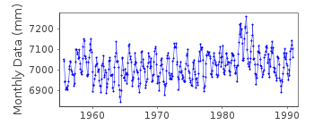
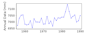
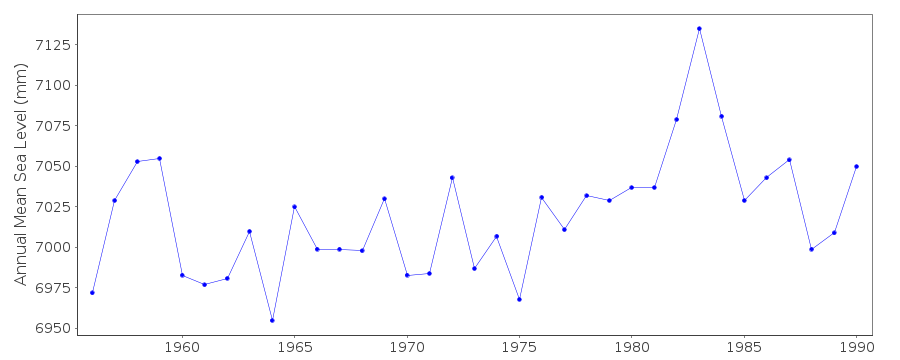
| Time span of data: | 1955 – 1990 |
| Completeness (%): | 98 |
| Date of last update: | 16 Jul 1993 |
| Green Arrow: | Current Station |
| Yellow Marker: | Neighbouring RLR Station |
| Red Marker: | Neighbouring Metric Station |
Please note: In many cases, the station position in our database is accurate to only one minute. Thus, the tide gauge may not appear to be on the coast.
Tide Gauge Data
Additional Data Sources (guide to additional data sources)
Nearby GNSS Stations from SONEL: FVPK, TRAKStation Documentation
Link to RLR information.Documentation added 1991-06-11
Newport Bay 823/057 RLR(1971) is 9.8m below BM1HPDocumentation added 2012-01-26
This is a historic station last data value received is that for December 1990. It was discovered that there was an error in the original RLR diagram. This gave the Primary benchmark as 1 HP when infact it should be 1 NP 1955. This has been rectified on the revised diagram. As no further data will be received from this station it has been marked 'inactive'.Data Authority
N.O.A.A. / N.O.S.N/oes33, Ssmc4, Room 6531
1305 East-West Highway
Silver Spring,
MD 20910

![]()
![]()
![]()
