Data
- Obtaining
- Supplying
- High-Frequency
- Bottom Pressure Records
- Other Long Records
- GLOSS/ODINAFRICA Calibration Data
Donate
Donate to PSMSL
Data Notes
- Individual Station Data and Plot Notes
- Referencing the Data Set
- PSMSL Help File
- 2010 Changes to the PSMSL Data Files
Extracted from Database
11 Mar 2024
Station Information
| Station ID: | 714 |
| Latitude: | 11.55 |
| Longitude: | -72.916667 |
| Coastline code: | 902 |
| Station code: | 11 |
| Country: | COLOMBIA |
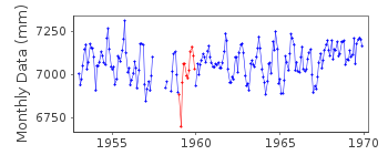
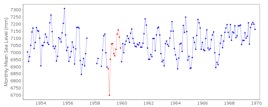
| Time span of RLR data: | 1953 – 1969 |
| RLR completeness (%): | 95 |
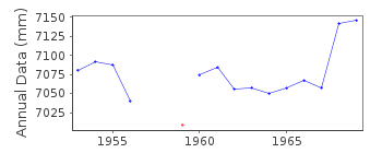
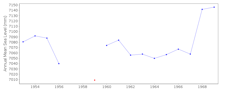
| Time span of metric data: | 1953 – 1976 |
| Metric completeness (%): | 95 |
| Date of last update: | 01 Jan 1980 |
| Green Arrow: | Current Station |
| Yellow Marker: | Neighbouring RLR Station |
| Red Marker: | Neighbouring Metric Station |
Please note: In many cases, the station position in our database is accurate to only one minute. Thus, the tide gauge may not appear to be on the coast.
Tide Gauge Data
Station Documentation
Link to RLR information.Documentation - date unknown
Prior to 1970 data supplied by N.O.A.A.Documentation added 1991-06-11
Riohacha 902/011 RLR(1964) is 10.3m below BM4Documentation added 1993-07-29
Anomalously low value for February 1959 - correct as received from authority.Data Authority
Instituto Geografico 'Agostin Codazzi'Carrera 30 No. 48-51
Bogota

![]()
![]()
![]()
