Data
- Obtaining
- Supplying
- High-Frequency
- Bottom Pressure Records
- Other Long Records
- GLOSS/ODINAFRICA Calibration Data
Donate
Donate to PSMSL
Data Notes
- Individual Station Data and Plot Notes
- Referencing the Data Set
- PSMSL Help File
- 2010 Changes to the PSMSL Data Files
Extracted from Database
11 Mar 2024
Station Information
| Station ID: | 683 |
| Latitude: | -41.050083 |
| Longitude: | 145.915 |
| Coastline code: | 680 |
| Station code: | 193 |
| Country: | AUSTRALIA |
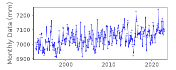
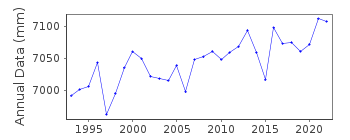
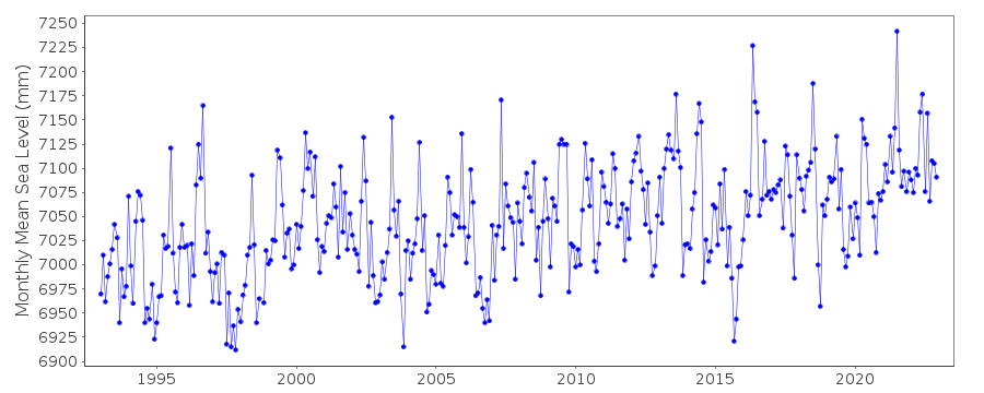
| Time span of RLR data: | 1993 – 2022 |
| RLR completeness (%): | 100 |
| Time span of metric data: | 1952 – 2022 |
| Metric completeness (%): | 72 |
| Link to ellipsoid: | Available |
| Date of last update: | 27 Feb 2023 |
| Green Arrow: | Current Station |
| Yellow Marker: | Neighbouring RLR Station |
| Red Marker: | Neighbouring Metric Station |
Please note: In many cases, the station position in our database is accurate to only one minute. Thus, the tide gauge may not appear to be on the coast.
Tide Gauge Data
Additional Data Sources (guide to additional data sources)
Nearby GNSS Stations from SONEL: RHPT, BUR2, BUR1Nearby Real Time Stations from VLIZ: barn
Research Quality Data from UHSLC station 344: hourly and daily
Station Documentation
Link to RLR information.Documentation added 1995-05-02
Station density along some sections of the Australian coast has meant that station codes 601 onwards have been re-ordered compared to those in earlier versions of the PSMSL data set.Documentation added 1996-03-28
Revised data supplied by the National Tidal Centre, Bureau of Meteorology, South Australia. SEAFRAME station installed 03/09/1992Documentation added 1996-03-28
Burnie is run by NTF/CSIRODocumentation added 2000-04-10
This is a "baseline station" of the Australian National Tidal Facility.Documentation added 2000-04-10
Burnie 680/193 RLR(2000) is 10.1m below SPM9087Documentation added 2011-10-24
Using information from the National Tidal Centre, Australia the RLR diagram has been revised. Primary benchmark is 5.0m above TGZ. Seaframe sensor benchmark 11090RM 1 is 6.535m above TGZ - This is the NTC Levelling fixture after July 2008. The national Datum AHD is 1.938m above TGZ. RLR factor is 5.1m.Documentation added 2018-10-03
Three Tasmanian stations Burnie, Devonport and Low Head have a spike in May 2016. When these are plotted together the spike gets larger as it travels around the coastline from Burnie to Devonport and finally to Low Head where the spike is so great it looks like an anomaly.Data Authority
National Tidal CentreBureau of Meteorology
PO Box 421
Kent Town 5071
South Australia
Documentation added 2010-08-12
Formerly known as the National Tidal Facility

![]()
![]()
![]()
