Data
- Obtaining
- Supplying
- High-Frequency
- Bottom Pressure Records
- Other Long Records
- GLOSS/ODINAFRICA Calibration Data
Donate
Donate to PSMSL
Data Notes
- Individual Station Data and Plot Notes
- Referencing the Data Set
- PSMSL Help File
- 2010 Changes to the PSMSL Data Files
Extracted from Database
11 Mar 2024
Station Information
| Station ID: | 57 |
| Latitude: | 63.081533 |
| Longitude: | 21.571183 |
| Coastline code: | 60 |
| Station code: | 51 |
| Country: | FINLAND |
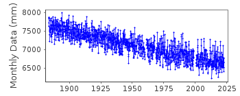
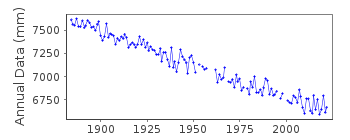
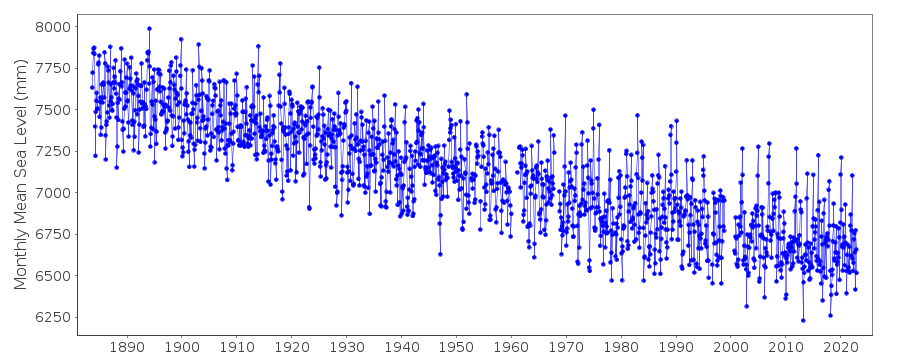
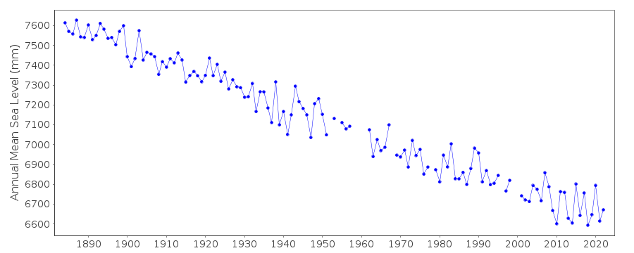
| Time span of data: | 1883 – 2022 |
| Completeness (%): | 95 |
| Date of last update: | 25 May 2023 |
| Green Arrow: | Current Station |
| Yellow Marker: | Neighbouring RLR Station |
| Red Marker: | Neighbouring Metric Station |
Please note: In many cases, the station position in our database is accurate to only one minute. Thus, the tide gauge may not appear to be on the coast.
Tide Gauge Data
Additional Data Sources (guide to additional data sources)
Nearby GNSS Stations from SONEL: VAA2, VAASStation Documentation
Link to RLR information.Documentation added 1991-06-11
Vaasa/Vasa 060/051 RLR(1964) is 8.0m below BM1139GDocumentation added 1993-07-12
Vaasa/Vasa 060/051 RLR(1964) is 8.0m below BM1139GDocumentation added 2002-09-24
A description of the sea level network in Finland can be foundin 'Operational Oceanography: Implementation at the European
and Regional scales. 2002 (pp.129-137)'.
1883-1921 FCODE=01
1922-1970 FCODE=06
Documentation added 2012-01-09
Levelling information recently supplied by the Finnish Meteorological Instituteconfirms that previous benchmark 1139G is no longer used. From 2000 onwards
Primary benchmark is 00003 3.294 above gauge datum. While this was being
reviewed it was noticed that data for the period Jan1919-Dec1921 was not
included as RLR leaving a gap in the RLR dataset. Although this was
investigated no reason was found for this anomaly. This data period has now
been included in the RLR dataset.
Documentation added 2017-01-31
Following the 2016 levelling exercise some adjustments have been made to the benchmark reference heights - at Vaasa this was +1mm for BM 00003. The adjustments are a result of more accurate measuring and calculations using the N2000 height system. The RLR diagram has been re-drawn because of this.Documentation added 2019-11-27
From 2018 onwards the averages of the Finnish sea level data will be based on 1 min observations. Values are calculated in Finnish normal time (EET).The data are relative to the reference surface of the Finnish sea level observations and thus the datum is the tide gauge zero.
Data Authority
Finnish Meteorological InstituteMarine Research, Waves and Sea Level
Erik Palenin aukio 1
P.O. Box 503
FI - 00101 Helsinki

![]()
![]()
![]()
