Data
- Obtaining
- Supplying
- High-Frequency
- Bottom Pressure Records
- Other Long Records
- GLOSS/ODINAFRICA Calibration Data
Donate
Donate to PSMSL
Data Notes
- Individual Station Data and Plot Notes
- Referencing the Data Set
- PSMSL Help File
- 2010 Changes to the PSMSL Data Files
Extracted from Database
11 Mar 2024
Station Information
| Station ID: | 558 |
| Latitude: | 13.333333 |
| Longitude: | -87.816667 |
| Coastline code: | 833 |
| Station code: | 1 |
| Country: | EL SALVADOR |
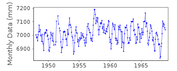
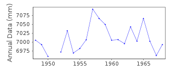
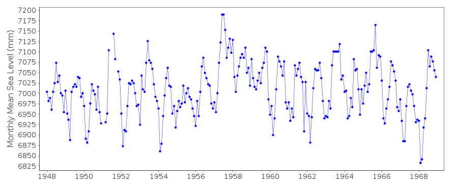
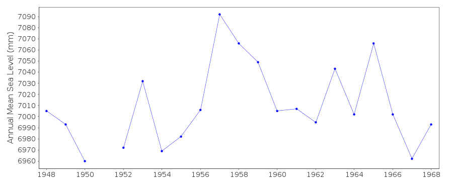
| Time span of data: | 1948 – 1968 |
| Completeness (%): | 98 |
| Date of last update: | 01 Jan 1980 |
| Green Arrow: | Current Station |
| Yellow Marker: | Neighbouring RLR Station |
| Red Marker: | Neighbouring Metric Station |
Please note: In many cases, the station position in our database is accurate to only one minute. Thus, the tide gauge may not appear to be on the coast.
Tide Gauge Data
Additional Data Sources (guide to additional data sources)
Nearby Real Time Stations from VLIZ: launResearch Quality Data from UHSLC station 86: hourly and daily
Station Documentation
Link to RLR information.Documentation added 1991-06-11
La Union 833/001 RLR(1964) is 11.0m below BM3Documentation added 2012-01-26
This is an historic station which is no longer referred to on the NOAA website. Last data value received is that for December 1968. Station has been labelled 'inactive'.Data Authority
N.O.A.A. / N.O.S.N/oes33, Ssmc4, Room 6531
1305 East-West Highway
Silver Spring,
MD 20910

![]()
![]()
![]()
