Data
- Obtaining
- Supplying
- High-Frequency
- Bottom Pressure Records
- Other Long Records
- GLOSS/ODINAFRICA Calibration Data
Donate
Donate to PSMSL
Data Notes
- Individual Station Data and Plot Notes
- Referencing the Data Set
- PSMSL Help File
- 2010 Changes to the PSMSL Data Files
Extracted from Database
11 Mar 2024
Station Information
| Station ID: | 545 |
| Latitude: | 25.133333 |
| Longitude: | 121.733333 |
| Coastline code: | 612 |
| Station code: | 2 |
| Country: | TAIWAN, PROVINCE OF CHINA |
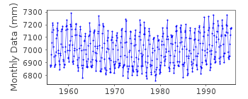
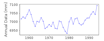
| Time span of RLR data: | 1956 – 1995 |
| RLR completeness (%): | 99 |
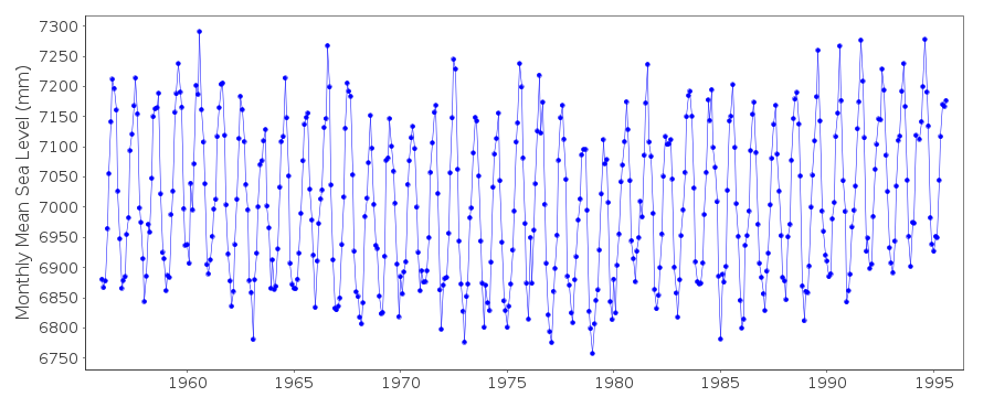
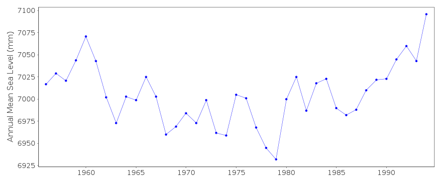
| Time span of metric data: | 1948 – 1995 |
| Metric completeness (%): | 98 |
| Date of last update: | 28 Apr 1998 |
| Green Arrow: | Current Station |
| Yellow Marker: | Neighbouring RLR Station |
| Red Marker: | Neighbouring Metric Station |
Please note: In many cases, the station position in our database is accurate to only one minute. Thus, the tide gauge may not appear to be on the coast.
Tide Gauge Data
Additional Data Sources (guide to additional data sources)
Nearby Real Time Stations from VLIZ: tzha, tkeeFast Delivery Data from UHSLC station 341: hourly and daily
Research Quality Data from UHSLC station 341: hourly and daily
Station Documentation
Link to RLR information.Documentation - date unknown
1948-1953 Sedimentation increasing, station re-positioned in 1956Documentation added 1991-06-11
Keelung II 612/002 RLR(1988) is 9.5m below BMDocumentation added 1996-02-26
Data 1990-91 received from TOGA officeData Authority
Central Weather Bureau64 Kung Yuan Road
Taipei
Taiwan 10039

![]()
![]()
![]()
