Data
- Obtaining
- Supplying
- High-Frequency
- Bottom Pressure Records
- Other Long Records
- GLOSS/ODINAFRICA Calibration Data
Donate
Donate to PSMSL
Data Notes
- Individual Station Data and Plot Notes
- Referencing the Data Set
- PSMSL Help File
- 2010 Changes to the PSMSL Data Files
Extracted from Database
11 Mar 2024
Station Information
| Station ID: | 522 |
| Latitude: | 13.15 |
| Longitude: | 123.75 |
| GLOSS ID: | 72 |
| Coastline code: | 660 |
| Station code: | 21 |
| Country: | PHILIPPINES |
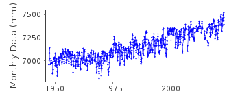
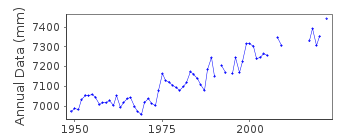
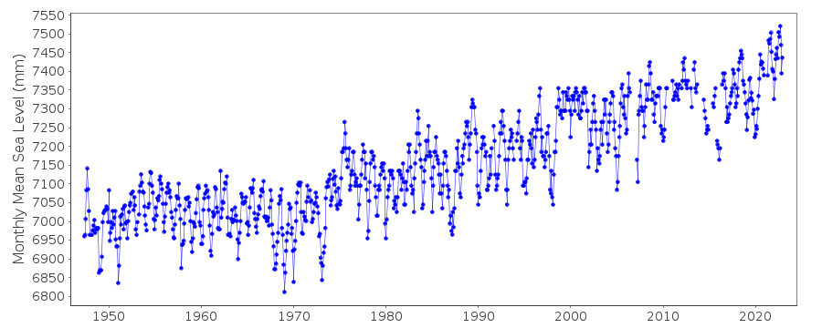
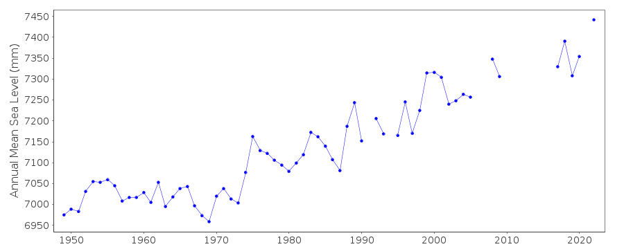
| Time span of data: | 1947 – 2022 |
| Completeness (%): | 94 |
| Date of last update: | 13 Jun 2023 |
| Green Arrow: | Current Station |
| Yellow Marker: | Neighbouring RLR Station |
| Red Marker: | Neighbouring Metric Station |
Please note: In many cases, the station position in our database is accurate to only one minute. Thus, the tide gauge may not appear to be on the coast.
Tide Gauge Data
Additional Data Sources (guide to additional data sources)
Nearby Real Time Stations from VLIZ: legaFast Delivery Data from UHSLC station 371: hourly and daily
Research Quality Data from UHSLC station 371: hourly and daily
Station Documentation
Link to RLR information.Documentation added 2002-03-27
Legaspi 660/021 RLR(1964) is 9.1m below BM1 (1961). Gauge type = Ott, (30th March 1999).BM1 (1961) disturbed October 1983, but datum of data unchanged.BM2 (1989) disturbed when pier repaired in 1994, but the datum of the data has remained unchanged.Documentation added 2010-10-14
There has been a number of changes to the datum value over the years as different levelling excercises have taken place.1947-1984 BM 1 3.675m above TSO 1947 1985-88 BM 1 3.702m above TSO 1947 see letter dated 22.01.1988 1989-1997 BM 2 3.818m above TSO 1947 1998-9 BM 2 3.790m above TSO 1947 2000-2002 BM 2 4.009m above TSO 1947 2003 benchmark name becomes B 22 2005-7 value rounded to 4.01m 2008 back to 4.009m Gauge type is THALIMEDES/SUTRON Different values were not included on the RLR diagram as the RLR factor does not changeData Authority
National Mapping and Resource Information AuthorityHydrography Department
421 Barraca St,
San Nicolas 1010
Manila

![]()
![]()
![]()
