Data
- Obtaining
- Supplying
- High-Frequency
- Bottom Pressure Records
- Other Long Records
- GLOSS/ODINAFRICA Calibration Data
Donate
Donate to PSMSL
Data Notes
- Individual Station Data and Plot Notes
- Referencing the Data Set
- PSMSL Help File
- 2010 Changes to the PSMSL Data Files
Extracted from Database
11 Mar 2024
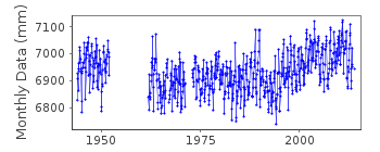
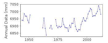
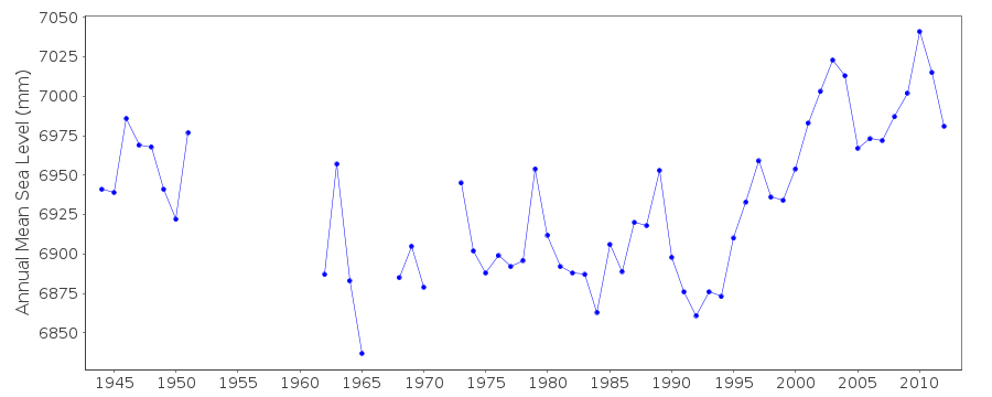
Station Information
| Station ID: | 496 |
| Latitude: | 36.7127 |
| Longitude: | -4.41546 |
| Coastline code: | 220 |
| Station code: | 31 |
| Country: | SPAIN |
| Time span of data: | 1944 – 2013 |
| Completeness (%): | 82 |
| Link to ellipsoid: | Available |
| Date of last update: | 27 Apr 2015 |
| Green Arrow: | Current Station |
| Yellow Marker: | Neighbouring RLR Station |
| Red Marker: | Neighbouring Metric Station |
Please note: In many cases, the station position in our database is accurate to only one minute. Thus, the tide gauge may not appear to be on the coast.
Tide Gauge Data
Additional Data Sources (guide to additional data sources)
Nearby GNSS Stations from SONEL: MALANearby Real Time Stations from VLIZ: mal3
Station Documentation
Link to RLR information.Documentation added 1998-10-13
all data 1944-97 revised, October 1998Documentation added 1998-10-13
1962:new tide gauge installationDocumentation added 2008-12-11
Database updated with a revised copy of the completedataset supplied by Maria Jesus. Previous values
copied and stored in file.
Documentation added 2010-10-25
As the dataset has been completely revised the suspect flag on the station hasbeen removed.
Documentation added 2014-09-03
Using values from a listing recently supplied by IEO the co-ordinates for Malaga have been revised.Data Authority
Instituto Español de OceanografíaCorazón de María, 8
28002, Madrid

![]()
![]()
![]()
