Data
- Obtaining
- Supplying
- High-Frequency
- Bottom Pressure Records
- Other Long Records
- GLOSS/ODINAFRICA Calibration Data
Donate
Donate to PSMSL
Data Notes
- Individual Station Data and Plot Notes
- Referencing the Data Set
- PSMSL Help File
- 2010 Changes to the PSMSL Data Files
Extracted from Database
11 Mar 2024
Station Information
| Station ID: | 454 |
| Latitude: | 48.641102 |
| Longitude: | -2.02818 |
| Coastline code: | 190 |
| Station code: | 71 |
| Country: | FRANCE |
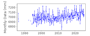
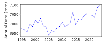
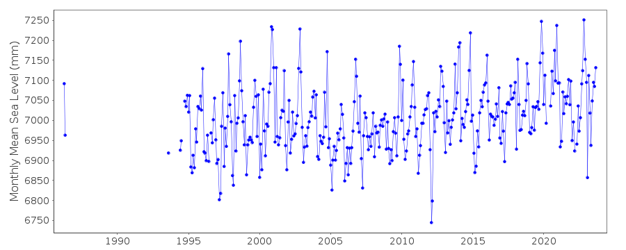
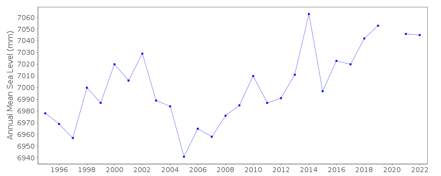
| Time span of RLR data: | 1986 – 2023 |
| RLR completeness (%): | 76 |
| Time span of metric data: | 1941 – 2023 |
| Metric completeness (%): | 40 |
| Link to ellipsoid: | Available |
| Date of last update: | 30 Jan 2024 |
| Green Arrow: | Current Station |
| Yellow Marker: | Neighbouring RLR Station |
| Red Marker: | Neighbouring Metric Station |
Please note: In many cases, the station position in our database is accurate to only one minute. Thus, the tide gauge may not appear to be on the coast.
Tide Gauge Data
Additional Data Sources (guide to additional data sources)
Nearby GNSS Stations from SONEL: DIPL, SMTGNearby Real Time Stations from VLIZ: stma2, stma
Station Documentation
Link to RLR information.Documentation added 2010-06-29
Following the input of the 2009 data this station was made RLR. RLR (2009) is14.700m below TGBM N.Q.K3L3-45. Add 0.215m to all data to refer to RLR (2009).
Documentation added 2014-10-01
After downloading the St Malo data from SONEL it was realised a lot of additional data for the 1990s and 2000s had been added. Because of this the whole dataset was re-loaded.Documentation added 2014-10-02
Also using data from SONEL the latitude and longitude for St. Malo has been updated.Data Authority
SHOM13 rue de Chatelier
29200 BREST

![]()
![]()
![]()
