Data
- Obtaining
- Supplying
- High-Frequency
- Bottom Pressure Records
- Other Long Records
- GLOSS/ODINAFRICA Calibration Data
Donate
Donate to PSMSL
Data Notes
- Individual Station Data and Plot Notes
- Referencing the Data Set
- PSMSL Help File
- 2010 Changes to the PSMSL Data Files
Extracted from Database
11 Mar 2024
Station Information
| Station ID: | 453 |
| Latitude: | 49.4819 |
| Longitude: | 0.106 |
| Coastline code: | 190 |
| Station code: | 51 |
| Country: | FRANCE |
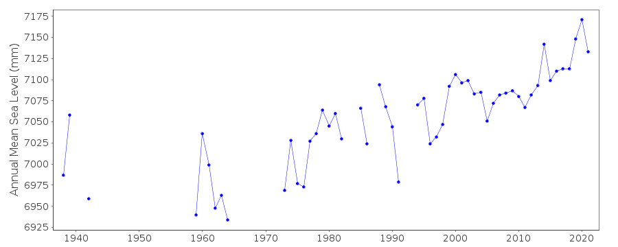
| Time span of data: | 1938 – 2023 |
| Completeness (%): | 68 |
| Date of last update: | 30 Jan 2024 |
| Green Arrow: | Current Station |
| Yellow Marker: | Neighbouring RLR Station |
| Red Marker: | Neighbouring Metric Station |
Please note: In many cases, the station position in our database is accurate to only one minute. Thus, the tide gauge may not appear to be on the coast.
Tide Gauge Data
Additional Data Sources (guide to additional data sources)
Nearby GNSS Stations from SONEL: FRANNearby Real Time Stations from VLIZ: leha2, leha
Station Documentation
Link to RLR information.Documentation - date unknown
1941-1942 data supplied by B.O.D.C.1959-1962 data supplied by the National Geographical Institute, France
Documentation added 1991-06-11
Le Havre 190/051 RLR(1977) is 12.7m below BM NGFNPC17Documentation added 1994-10-21
1991-93 problems with gauge operation, numerous gapsDocumentation added 2012-03-28
Primary benchmark is now IGN N.CP-15 9.767m above Zero Hydrographique.Documentation added 2014-09-24
Using values from the SONEL website the latitude and longitude for Le Havre has been revised. The data downloaded from SONEL contained a number of additional data points particularly for the 1980's. Because of this the whole dataset has been re-loaded.Data Authority
SHOM13 rue de Chatelier
29200 BREST

![]()
![]()
![]()
