Data
- Obtaining
- Supplying
- High-Frequency
- Bottom Pressure Records
- Other Long Records
- GLOSS/ODINAFRICA Calibration Data
Donate
Donate to PSMSL
Data Notes
- Individual Station Data and Plot Notes
- Referencing the Data Set
- PSMSL Help File
- 2010 Changes to the PSMSL Data Files
Extracted from Database
11 Mar 2024
Station Information
| Station ID: | 418 |
| Latitude: | 19.906667 |
| Longitude: | -75.146667 |
| Coastline code: | 930 |
| Station code: | 51 |
| Country: | CUBA |
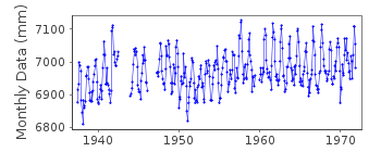
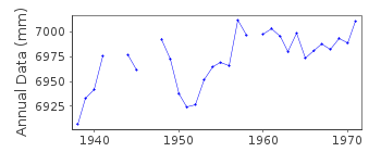
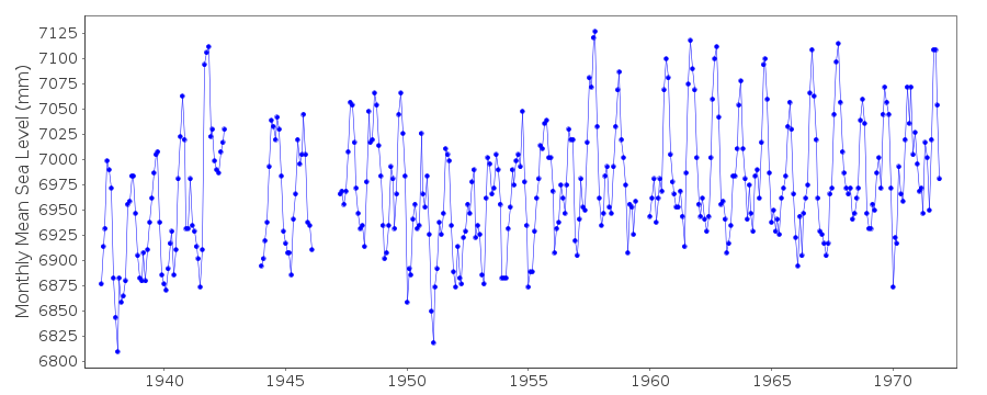
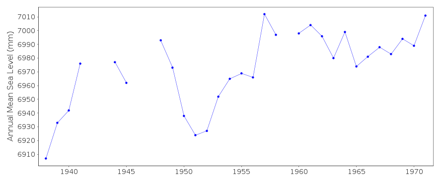
| Time span of data: | 1937 – 1971 |
| Completeness (%): | 90 |
| Date of last update: | 17 Jul 2001 |
| Green Arrow: | Current Station |
| Yellow Marker: | Neighbouring RLR Station |
| Red Marker: | Neighbouring Metric Station |
Please note: In many cases, the station position in our database is accurate to only one minute. Thus, the tide gauge may not appear to be on the coast.
Tide Gauge Data
Additional Data Sources (guide to additional data sources)
Research Quality Data from UHSLC station 251: hourly and dailyStation Documentation
Link to RLR information.Documentation added 1991-06-11
Guantanamo Bay 930/051 RLR(1964) is 16.1m below BM1Documentation added 1993-07-12
Guantanamo Bay 930/051 RLR(1964) is 16.1m below BM1Documentation added 2011-11-23
Guantanamo Bay does feature on the Historic Data page on the NOAA websitebut there is no very little metadata available for this station.
Data Authority
N.O.A.A. / N.O.S.N/oes33, Ssmc4, Room 6531
1305 East-West Highway
Silver Spring,
MD 20910

![]()
![]()
![]()
