Data
- Obtaining
- Supplying
- High-Frequency
- Bottom Pressure Records
- Other Long Records
- GLOSS/ODINAFRICA Calibration Data
Donate
Donate to PSMSL
Data Notes
- Individual Station Data and Plot Notes
- Referencing the Data Set
- PSMSL Help File
- 2010 Changes to the PSMSL Data Files
Extracted from Database
11 Mar 2024
WARNING: QCFLAG EXISTS. PLEASE READ THE DOCUMENTATION.
Station Information
| Station ID: | 39 |
| Latitude: | 45.416667 |
| Longitude: | 12.333333 |
| Coastline code: | 270 |
| Station code: | 51 |
| Country: | ITALY |
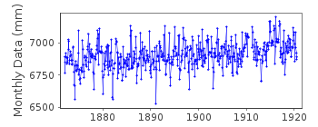
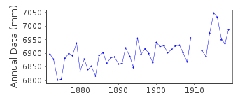
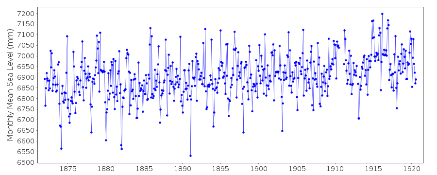
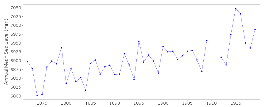
| Time span of data: | 1872 – 1920 |
| Completeness (%): | 98 |
| Date of last update: | 11 Apr 2000 |
| Green Arrow: | Current Station |
| Yellow Marker: | Neighbouring RLR Station |
| Red Marker: | Neighbouring Metric Station |
Please note: In many cases, the station position in our database is accurate to only one minute. Thus, the tide gauge may not appear to be on the coast.
Tide Gauge Data
Additional Data Sources (guide to additional data sources)
Nearby GNSS Stations from SONEL: VENE, VEN1, VEAR, VENI, PSALNearby Real Time Stations from VLIZ: VE19
Station Documentation
Link to RLR information.Documentation - date unknown
For a discussion of submergence near to Venice see Emery and Aubrey (Sea Levels, Land Levels and Tide Gauges), 1991, Springer-Verlag, page 34.Documentation added 1999-11-23
Venezia(S.Stefano) 270/051 RLR(1919) is 9.9m below BM Palace FacadeDocumentation added 1999-11-23
The San Stefano gauge was moved to a new position on 26 August 1911.Documentation added 1999-11-24
RLR values for Venice San Stefano (270/051) and Punta della Salute (270/054) should be to essentially the same datum enabling one composite record to be made.Documentation added 2000-04-11
Data in the San Stefano record for 1872-1886 come via Dr Paolo Pirazzoli from F.C.Rossi, 1887, Il Commune Marino di Venezia. Data for 1887-1895 were obtained from Paolo Pirazzoli in March 2000. Later data came from Instituto Idrografico Della Marina, Genova. All data are MTL rather than MSL.Data Authority
Istituto Idrografico della MarinaPasso Osservatorio 4
16134 Genova

![]()
![]()
![]()
