Data
- Obtaining
- Supplying
- High-Frequency
- Bottom Pressure Records
- Other Long Records
- GLOSS/ODINAFRICA Calibration Data
Donate
Donate to PSMSL
Data Notes
- Individual Station Data and Plot Notes
- Referencing the Data Set
- PSMSL Help File
- 2010 Changes to the PSMSL Data Files
Extracted from Database
11 Mar 2024
Station Information
| Station ID: | 379 |
| Latitude: | 44.166667 |
| Longitude: | 28.666667 |
| Coastline code: | 297 |
| Station code: | 21 |
| Country: | ROMANIA |
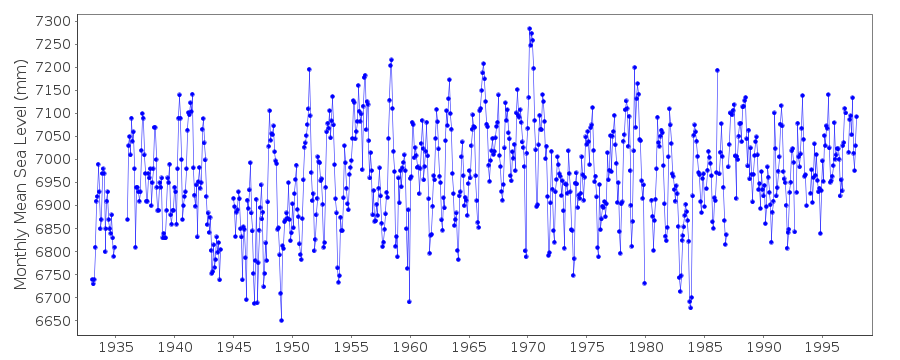
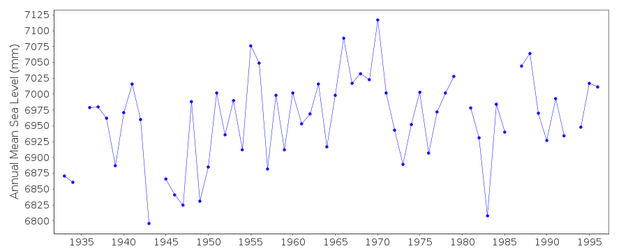
| Time span of data: | 1933 – 1997 |
| Completeness (%): | 95 |
| Date of last update: | 01 Jul 1998 |
| Green Arrow: | Current Station |
| Yellow Marker: | Neighbouring RLR Station |
| Red Marker: | Neighbouring Metric Station |
Please note: In many cases, the station position in our database is accurate to only one minute. Thus, the tide gauge may not appear to be on the coast.
Tide Gauge Data
Additional Data Sources (guide to additional data sources)
Nearby GNSS Stations from SONEL: CONB, COSTNearby Real Time Stations from VLIZ: csta2
Station Documentation
Link to RLR information.Documentation added 1999-03-10
For a discussion on sea level trends along Black Sea coastssee Variations of the Black Sea Level by S.G.Boguslavsky et al.,
Physical Oceanography, 9(3), 199-208, 1998.
Documentation added 1999-03-10
Romanian sea levels likely to be heavily influenced by river flow.Documentation added 1999-03-10
See also comments under Bourgas (code 295/021).Documentation added 2000-01-25
Constantza 297/021 RLR(1996) is 9.3m below BM bronze square plateDocumentation added 2011-03-08
Datum of the data - Tide Gauge Zero is 2.48m below the Primary benchmark.Data Authority
Romanian Marine Research InstituteBd. Mamaia 300
Constantza 8700

![]()
![]()
![]()
