Data
- Obtaining
- Supplying
- High-Frequency
- Bottom Pressure Records
- Other Long Records
- GLOSS/ODINAFRICA Calibration Data
Donate
Donate to PSMSL
Data Notes
- Individual Station Data and Plot Notes
- Referencing the Data Set
- PSMSL Help File
- 2010 Changes to the PSMSL Data Files
Extracted from Database
11 Mar 2024
Station Information
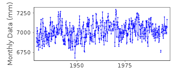
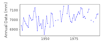
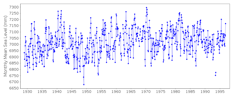
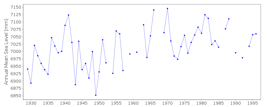
| Station ID: | 318 |
| Latitude: | 43.183333 |
| Longitude: | 27.916667 |
| Coastline code: | 295 |
| Station code: | 51 |
| Country: | BULGARIA |
| Time span of RLR data: | 1929 – 1996 |
| RLR completeness (%): | 95 |
| Time span of metric data: | 1928 – 1996 |
| Metric completeness (%): | 94 |
| Date of last update: | 27 Aug 1997 |
| Green Arrow: | Current Station |
| Yellow Marker: | Neighbouring RLR Station |
| Red Marker: | Neighbouring Metric Station |
Please note: In many cases, the station position in our database is accurate to only one minute. Thus, the tide gauge may not appear to be on the coast.
Tide Gauge Data
Station Documentation
Link to RLR information.Documentation added 1997-08-27
The site of the tide gauge is subject to subsidence. During the period1929-95 the datum of observations has sunk 0.510m.
Documentation added 1999-03-10
For a discussion on sea level trends along Black Sea coastssee Variations of the Black Sea Level by S.G.Boguslavsky et al.,
Physical Oceanography, 9(3), 199-208, 1998.
Documentation added 1999-03-10
Bulgarian sea levels likely to be heavily influenced by river flow.Documentation added 1999-03-10
New gauge established at Varna in 1985.Documentation added 1999-03-10
See also comments under Bourgas (code 295/021).Documentation added 2000-01-25
Varna 295/051 RLR(1939) is 40.4m below BM no. 11Data Authority
Min. of Regional Dev. and ConstructionResearch Institute of Geodesy and Photogrammetry
1 Moussala Str.
1618 Sofia

![]()
![]()
![]()
