Data
- Obtaining
- Supplying
- High-Frequency
- Bottom Pressure Records
- Other Long Records
- GLOSS/ODINAFRICA Calibration Data
Donate
Donate to PSMSL
Data Notes
- Individual Station Data and Plot Notes
- Referencing the Data Set
- PSMSL Help File
- 2010 Changes to the PSMSL Data Files
Extracted from Database
11 Mar 2024
Station Information
| Station ID: | 300 |
| Latitude: | 19.73 |
| Longitude: | -155.055 |
| GLOSS ID: | 287 |
| Coastline code: | 760 |
| Station code: | 61 |
| Country: | UNITED STATES |
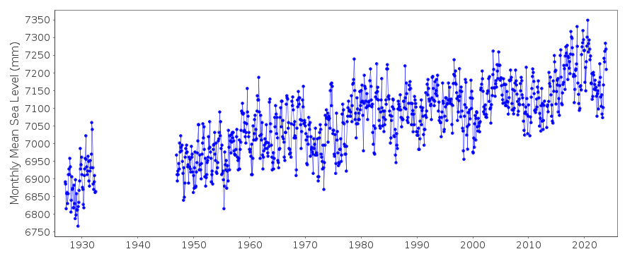
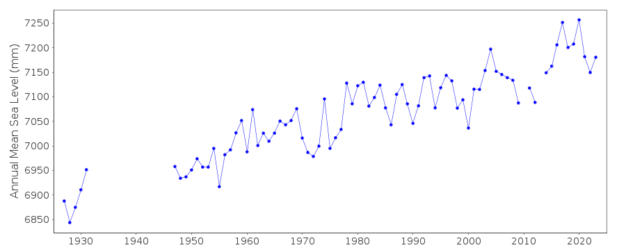
| Time span of data: | 1927 – 2023 |
| Completeness (%): | 85 |
| Date of last update: | 26 Jan 2024 |
| Green Arrow: | Current Station |
| Yellow Marker: | Neighbouring RLR Station |
| Red Marker: | Neighbouring Metric Station |
Please note: In many cases, the station position in our database is accurate to only one minute. Thus, the tide gauge may not appear to be on the coast.
Tide Gauge Data
Additional Data Sources (guide to additional data sources)
Nearby GNSS Stations from SONEL: HILR, HILONearby Real Time Stations from VLIZ: hilo, hilo2
Fast Delivery Data from UHSLC station 60: hourly and daily
Research Quality Data from UHSLC station 60: hourly and daily
Station Documentation
Link to RLR information.Documentation added 1991-06-11
Hilo 760/061 RLR(1964) is 9.3m below E2Documentation added 2011-08-31
Using NOAA data the RLR diagram has been re-drawn.From the current report of 2003 the Primary benchmark is NO 4 1951 4.663m TGZ. The previous benchmark E2 was 3.746m above TGZ. Although there is a benchmark in the current report labelled E2 1926 the values for this are in 2000 3.715m above TGZ and in 2003 3.714m above TGZ. Obviosly this indicates that the benchmark may be slightly unstable.Data Authority
N.O.A.A. / N.O.S.N/oes33, Ssmc4, Room 6531
1305 East-West Highway
Silver Spring,
MD 20910

![]()
![]()
![]()
