Data
- Obtaining
- Supplying
- High-Frequency
- Bottom Pressure Records
- Other Long Records
- GLOSS/ODINAFRICA Calibration Data
Donate
Donate to PSMSL
Data Notes
- Individual Station Data and Plot Notes
- Referencing the Data Set
- PSMSL Help File
- 2010 Changes to the PSMSL Data Files
Extracted from Database
11 Mar 2024
Station Information
| Station ID: | 266 |
| Latitude: | 60.12 |
| Longitude: | -149.426667 |
| GLOSS ID: | 150 |
| Coastline code: | 821 |
| Station code: | 17 |
| Country: | UNITED STATES |
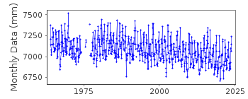
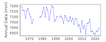
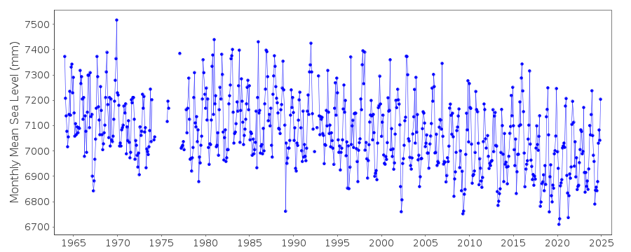
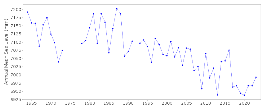
| Time span of RLR data: | 1964 – 2023 |
| RLR completeness (%): | 94 |
| Time span of metric data: | 1925 – 2023 |
| Metric completeness (%): | 88 |
| Date of last update: | 16 Jan 2024 |
| Green Arrow: | Current Station |
| Yellow Marker: | Neighbouring RLR Station |
| Red Marker: | Neighbouring Metric Station |
Please note: In many cases, the station position in our database is accurate to only one minute. Thus, the tide gauge may not appear to be on the coast.
Tide Gauge Data
Additional Data Sources (guide to additional data sources)
Nearby GNSS Stations from SONEL: AKSENearby Real Time Stations from VLIZ: sewa, sewa2
Fast Delivery Data from UHSLC station 560: hourly and daily
Research Quality Data from UHSLC station 560: hourly and daily
Station Documentation
Link to RLR information.Documentation added 1991-06-11
Seward 821/017 RLR(1972) is 13.0m below BM22Documentation added 1992-04-02
SOUTH ALASKAN COASTLINE EARTHQUAKE PRONE - E.G. MAGNITUDE 9.2 EARTHQUAKE OF 28 MARCH 1964 - SEE SAVAGE AND PLAFKER, JGR, 96(B3), 4325-4335, 1991 1964 - 1966 GAUGE SITED ON RAILWAY WHARF1966 TO DATE , GAUGE SITED ON ALASKA RAILROAD PIER
Documentation added 2011-08-25
Using NOAA data the RLR diagram has been re-drawn. Data for the period 1925-1963 referred to benchmark BM K-11 which now no longer appears in the NOAA reports. Primary benchmark is now 5090 B 1978 8.314m above gauge datum. The previously used benchmark NO 22 1966 still exists at 9.458m above gauge datum.Data Authority
N.O.A.A. / N.O.S.N/oes33, Ssmc4, Room 6531
1305 East-West Highway
Silver Spring,
MD 20910

![]()
![]()
![]()
