Data
- Obtaining
- Supplying
- High-Frequency
- Bottom Pressure Records
- Other Long Records
- GLOSS/ODINAFRICA Calibration Data
Donate
Donate to PSMSL
Data Notes
- Individual Station Data and Plot Notes
- Referencing the Data Set
- PSMSL Help File
- 2010 Changes to the PSMSL Data Files
Extracted from Database
11 Mar 2024
Station Information
| Station ID: | 26 |
| Latitude: | 56.533333 |
| Longitude: | 20.983333 |
| Coastline code: | 83 |
| Station code: | 151 |
| Country: | LATVIA |
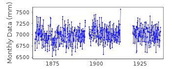
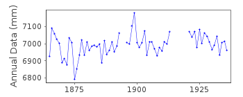
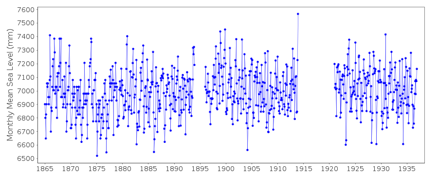
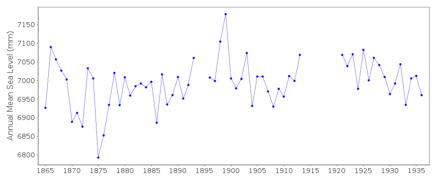
| Time span of data: | 1865 – 1936 |
| Completeness (%): | 88 |
| Date of last update: | 30 Mar 2016 |
| Green Arrow: | Current Station |
| Yellow Marker: | Neighbouring RLR Station |
| Red Marker: | Neighbouring Metric Station |
Please note: In many cases, the station position in our database is accurate to only one minute. Thus, the tide gauge may not appear to be on the coast.
Tide Gauge Data
Additional Data Sources (guide to additional data sources)
Nearby GNSS Stations from SONEL: LIPJ, LIP2, LIEPStation Documentation
Link to RLR information.Documentation - date unknown
1865-1893,1896-1913,1921-1927,1937 VALUES BASED ON 1 READING PER DAYDocumentation added 1991-06-11
Liepaja 080/151 RLR(1936) is 7.2m below BM LighthouseDocumentation added 1993-07-12
Liepaja 080/151 RLR(1936) is 7.2m below BM LighthouseDocumentation added 1993-07-29
Large value in December 1913 common to more than one station (seealso Hel, ID 146).
Documentation added 1994-07-11
This station is in Latvia.Liepaja is an historic station last data 1936
Documentation added 2016-03-30
Data flags removed for 1913 - as mentioned above, the extreme value for December 1913 also appears in nearby records.Data Authority
World Data CenterRussian Federal Service for Hydrometeorology
and Environmental Monitoring
6 Korolev Street, 249035 Obninsk
Kaluga Region

![]()
![]()
![]()
