Data
- Obtaining
- Supplying
- High-Frequency
- Bottom Pressure Records
- Other Long Records
- GLOSS/ODINAFRICA Calibration Data
Donate
Donate to PSMSL
Data Notes
- Individual Station Data and Plot Notes
- Referencing the Data Set
- PSMSL Help File
- 2010 Changes to the PSMSL Data Files
Extracted from Database
11 Mar 2024
Station Information
| Station ID: | 257 |
| Latitude: | 51.507667 |
| Longitude: | -2.71275 |
| Coastline code: | 170 |
| Station code: | 171 |
| Country: | UNITED KINGDOM |
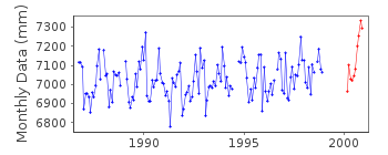
| Time span of RLR data: | 1986 – 2000 |
| RLR completeness (%): | 83 |
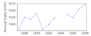
| Time span of metric data: | 1924 – 2012 |
| Metric completeness (%): | 90 |
| MTL Data: | 1959-1972, 1976-1981, 1983-1985 |
| MTL-MSL (mm): | 127 |
| Date of last update: | 27 Jan 2016 |
| Green Arrow: | Current Station |
| Yellow Marker: | Neighbouring RLR Station |
| Red Marker: | Neighbouring Metric Station |
Please note: In many cases, the station position in our database is accurate to only one minute. Thus, the tide gauge may not appear to be on the coast.
Tide Gauge Data
Additional Data Sources (guide to additional data sources)
Nearby Real Time Stations from VLIZ: sscr, avonStation Documentation
Link to RLR information.Documentation added 1993-10-11
1959-72, 1976-81, 1983-85 FCODE=HL, Some months based on incomplete data more details available on request.Documentation added 1994-09-21
Gauge was a stilling well (instrument made at Port of Bristol to Tidal Institute specification) until the end of 1984 with tabulations supplied by the Port of Bristol authority.From 21 November 1984 the gauge has been an "A Class" bubbler.Documentation added 2001-01-02
Recent work on vertical land movements in the UK can be found from the University of Nottingham web site:http://ukcogr.iessg.nottingham.ac.uk/~eosi/Documentation added 2001-03-21
Avonmouth - 170/171 RLR(1992) is 15.8m below TGBM ST 5057 7881Documentation added 2009-01-28
Treat data 2000 onwards as suspect.Documentation added 2010-06-08
Although the Avonmouth gauge is still operational the jetty on which the gauge stands is collapsing. A replacement gauge has been installed at Portbury.Documentation added 2016-01-22
A value of MTL-MSL=127 mm has been derived using from the GESLA2 (high-frequency tide gauge) dataset using harmonic constituents. As the correction is only applied to RLR data and the data during the periods 1959-1972, 1976-1981, and 1983-1985 are metric, it is not used in the data set. Should these periods become RLR in future, however, a correction for MTL-MSL would be needed. The 001 flag has been set only because this correction is highly uncertain.Data Authority
Horizon HouseDeanery Road
BS1 5AH
Bristol

![]()
![]()
![]()
