Data
- Obtaining
- Supplying
- High-Frequency
- Bottom Pressure Records
- Other Long Records
- GLOSS/ODINAFRICA Calibration Data
Donate
Donate to PSMSL
Data Notes
- Individual Station Data and Plot Notes
- Referencing the Data Set
- PSMSL Help File
- 2010 Changes to the PSMSL Data Files
Extracted from Database
11 Mar 2024
Station Information
| Station ID: | 245 |
| Latitude: | 33.72 |
| Longitude: | -118.271667 |
| Coastline code: | 823 |
| Station code: | 51 |
| Country: | UNITED STATES |
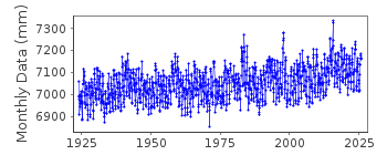
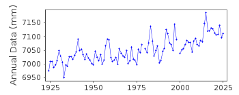
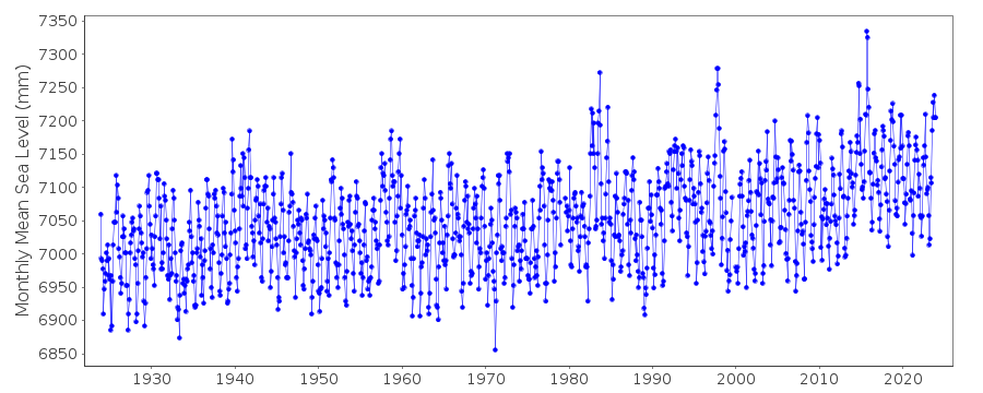
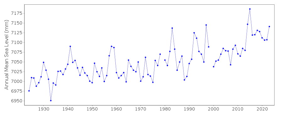
| Time span of data: | 1923 – 2023 |
| Completeness (%): | 98 |
| Date of last update: | 10 Jan 2024 |
| Green Arrow: | Current Station |
| Yellow Marker: | Neighbouring RLR Station |
| Red Marker: | Neighbouring Metric Station |
Please note: In many cases, the station position in our database is accurate to only one minute. Thus, the tide gauge may not appear to be on the coast.
Tide Gauge Data
Additional Data Sources (guide to additional data sources)
Nearby GNSS Stations from SONEL: CRHS, TORP, VTISResearch Quality Data from UHSLC station 567: hourly and daily
Station Documentation
Link to RLR information.Documentation added 1991-06-11
Los Angeles 823/051 RLR(1964) is 10.4m below BM8Documentation added 1994-07-14
For a discussion of submergence near to Los Angeles and Long Beach see Emery and Aubrey (Sea Levels, Land Levels and Tide Gauges), 1991, Springer-Verlag, page 39.Documentation added 2011-08-25
Using NOAA data the RLR diagram has been re-drawn. Primary benchmark remains BM8 5.361m above gauge datum but has now been given its official title 8 -14FT ABOVE MLLW to agree with the NOAA website.For information: Data values during the 1980's can look high. This could be due to the El Nino Southern Oscillation (ENSO) as it is mirrored along the Californian coast.
Data Authority
N.O.A.A. / N.O.S.N/oes33, Ssmc4, Room 6531
1305 East-West Highway
Silver Spring,
MD 20910

![]()
![]()
![]()
