Data
- Obtaining
- Supplying
- High-Frequency
- Bottom Pressure Records
- Other Long Records
- GLOSS/ODINAFRICA Calibration Data
Donate
Donate to PSMSL
Data Notes
- Individual Station Data and Plot Notes
- Referencing the Data Set
- PSMSL Help File
- 2010 Changes to the PSMSL Data Files
Extracted from Database
11 Mar 2024
Station Information
| Station ID: | 240 |
| Latitude: | 64.666333 |
| Longitude: | 24.40705 |
| Coastline code: | 60 |
| Station code: | 21 |
| Country: | FINLAND |
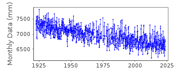
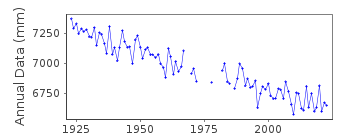
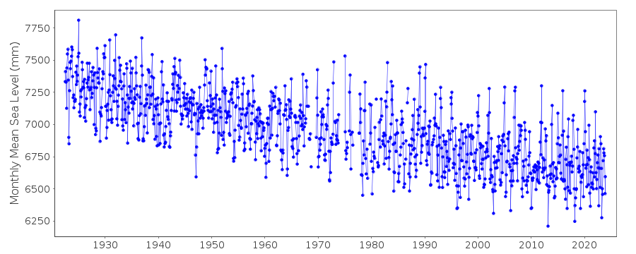
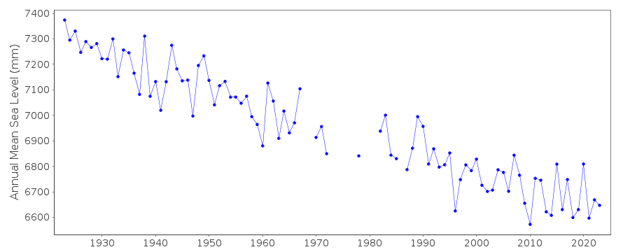
| Time span of data: | 1922 – 2023 |
| Completeness (%): | 93 |
| Date of last update: | 05 Mar 2024 |
| Green Arrow: | Current Station |
| Yellow Marker: | Neighbouring RLR Station |
| Red Marker: | Neighbouring Metric Station |
Please note: In many cases, the station position in our database is accurate to only one minute. Thus, the tide gauge may not appear to be on the coast.
Tide Gauge Data
Station Documentation
Link to RLR information.Documentation added 2002-09-24
A description of the sea level network in Finland can be foundin 'Operational Oceanography: Implementation at the European
and Regional scales. 2002 (pp.129-137)'.
PRIOR TO 1971 FCODE=06
PRIOR TO 1977 GAUGE AT 64 42 N, 24 30 E CLAIMED CONNECTABLE
This station was formerly known as Hornankallis in the Publication Scientifique.
Documentation added 2012-01-04
From levelling information supplied by the Finnish Meteorological Institutegauge site lat. and long and BM details as follows:
1922-1976 64 42 24 30 1294Y
1977-1996 64 39 24 25 83151
The above two benchmarks refer to the old tide gauge.
1997- 64 40 24 24 92409 (1992)
95403 (1995)
It was decided to refer to 92409 (1992) as the Primary Benchmark as it also
appears in the levelling report for 2006 whereas 95403 (1995)does not.
Documentation added 2017-01-31
Following the 2016 levelling exercise some adjustments have been made to the benchmark reference heights - at Raahe this was -1mm for BM 95403. The adjustments are a result of more accurate measuring and calculations using the N2000 height system. The RLR diagram has been re-drawn because of this.Documentation added 2019-11-27
From 2018 onwards the averages of the Finnish sea level data will be based on 1 min observations. Values are calculated in Finnish normal time (EET).The data are relative to the reference surface of the Finnish sea level observations and thus the datum is the tide gauge zero.
Data Authority
Finnish Meteorological InstituteMarine Research, Waves and Sea Level
Erik Palenin aukio 1
P.O. Box 503
FI - 00101 Helsinki

![]()
![]()
![]()
