Data
- Obtaining
- Supplying
- High-Frequency
- Bottom Pressure Records
- Other Long Records
- GLOSS/ODINAFRICA Calibration Data
Donate
Donate to PSMSL
Data Notes
- Individual Station Data and Plot Notes
- Referencing the Data Set
- PSMSL Help File
- 2010 Changes to the PSMSL Data Files
Extracted from Database
11 Mar 2024
Station Information
| Station ID: | 2242 |
| Latitude: | -17.8059 |
| Longitude: | -149.295 |
| Coastline code: | 780 |
| Station code: | 12 |
| Country: | FRENCH POLYNESIA |
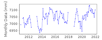
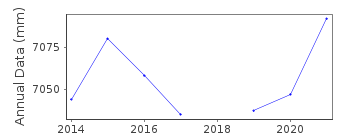
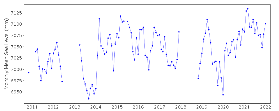
| Time span of RLR data: | 2010 – 2022 |
| RLR completeness (%): | 72 |
| Time span of metric data: | 1973 – 2022 |
| Metric completeness (%): | 20 |
| Link to ellipsoid: | Available |
| Date of last update: | 20 Oct 2022 |
| Green Arrow: | Current Station |
| Yellow Marker: | Neighbouring RLR Station |
| Red Marker: | Neighbouring Metric Station |
Please note: In many cases, the station position in our database is accurate to only one minute. Thus, the tide gauge may not appear to be on the coast.
Tide Gauge Data
Additional Data Sources (guide to additional data sources)
Nearby GNSS Stations from SONEL: VRTGNearby Real Time Stations from VLIZ: vair
Station Documentation
Link to RLR information.Documentation added 2016-06-21
Data for Vairao French Polynesia has only recently been added to the database. There is a small amount of data for August-November 1973 with the main dataset then beginning November 2010.Documentation added 2017-03-23
Using information from the SONEL website Vairao has been made RLR from 2010 onwards.Data Authority
SHOM13 rue de Chatelier
29200 BREST

![]()
![]()
![]()
