Data
- Obtaining
- Supplying
- High-Frequency
- Bottom Pressure Records
- Other Long Records
- GLOSS/ODINAFRICA Calibration Data
Donate
Donate to PSMSL
Data Notes
- Individual Station Data and Plot Notes
- Referencing the Data Set
- PSMSL Help File
- 2010 Changes to the PSMSL Data Files
Extracted from Database
11 Mar 2024
Station Information
| Station ID: | 2228 |
| Latitude: | 25.295833 |
| Longitude: | 60.603333 |
| GLOSS ID: | 337 |
| Coastline code: | 489 |
| Station code: | 52 |
| Country: | IRAN, ISLAMIC REPUBLIC OF |
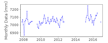
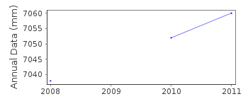
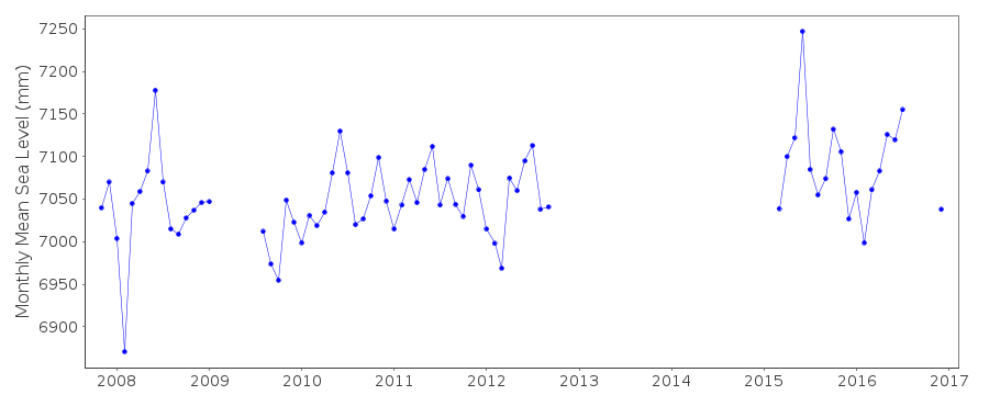
| Time span of data: | 2007 – 2016 |
| Completeness (%): | 59 |
| Date of last update: | 30 Nov 2017 |
| Green Arrow: | Current Station |
| Yellow Marker: | Neighbouring RLR Station |
| Red Marker: | Neighbouring Metric Station |
Please note: In many cases, the station position in our database is accurate to only one minute. Thus, the tide gauge may not appear to be on the coast.
Tide Gauge Data
Additional Data Sources (guide to additional data sources)
Fast Delivery Data from UHSLC station 915: hourly and dailyResearch Quality Data from UHSLC station 915: hourly and daily
Data Authority
Hydrographic DepartmentNational Cartographic Centre of Iran
Meraj Avenue
Azadi Square
Tehran

![]()
![]()
![]()
