Data
- Obtaining
- Supplying
- High-Frequency
- Bottom Pressure Records
- Other Long Records
- GLOSS/ODINAFRICA Calibration Data
Donate
Donate to PSMSL
Data Notes
- Individual Station Data and Plot Notes
- Referencing the Data Set
- PSMSL Help File
- 2010 Changes to the PSMSL Data Files
Extracted from Database
11 Mar 2024
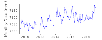
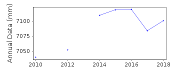
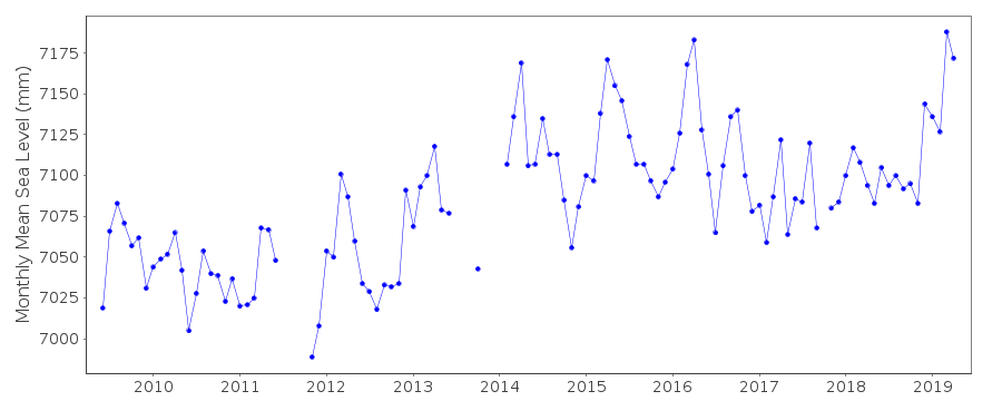
Station Information
| Station ID: | 2216 |
| Latitude: | -14.945812 |
| Longitude: | -147.706045 |
| GLOSS ID: | 355 |
| Coastline code: | 808 |
| Station code: | 2 |
| Country: | FRENCH POLYNESIA |
| Time span of data: | 2009 – 2019 |
| Completeness (%): | 82 |
| Link to ellipsoid: | Available |
| Date of last update: | 10 Nov 2020 |
| Green Arrow: | Current Station |
| Yellow Marker: | Neighbouring RLR Station |
| Red Marker: | Neighbouring Metric Station |
Please note: In many cases, the station position in our database is accurate to only one minute. Thus, the tide gauge may not appear to be on the coast.
Tide Gauge Data
Additional Data Sources (guide to additional data sources)
Nearby GNSS Stations from SONEL: RGTGNearby Real Time Stations from VLIZ: rangi
Fast Delivery Data from UHSLC station 455: hourly and daily
Station Documentation
Link to RLR information.Documentation added 2014-02-18
Rangiroa is a new station. Using levelling information from SONEL the station was made RLR.Documentation added 2014-10-01
Using data from the SONEL website the latitude and longitude for Rangiroa has been updated.Data Authority
SHOM13 rue de Chatelier
29200 BREST

![]()
![]()
![]()
