Data
- Obtaining
- Supplying
- High-Frequency
- Bottom Pressure Records
- Other Long Records
- GLOSS/ODINAFRICA Calibration Data
Donate
Donate to PSMSL
Data Notes
- Individual Station Data and Plot Notes
- Referencing the Data Set
- PSMSL Help File
- 2010 Changes to the PSMSL Data Files
Extracted from Database
11 Mar 2024
Station Information
| Station ID: | 217 |
| Latitude: | -36.84307 |
| Longitude: | 174.76946 |
| GLOSS ID: | 127 |
| Coastline code: | 690 |
| Station code: | 1 |
| Country: | NEW ZEALAND |
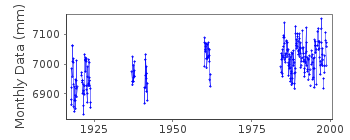
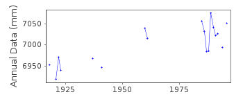
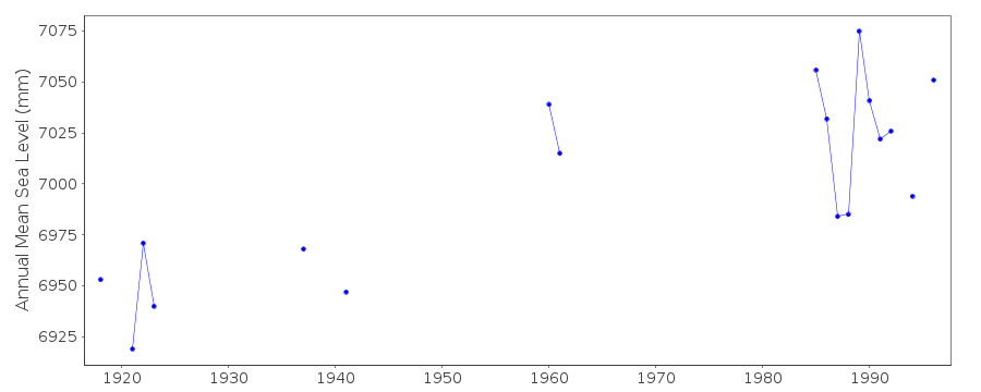
| Time span of data: | 1917 – 1998 |
| Completeness (%): | 27 |
| Date of last update: | 27 Aug 1999 |
| Green Arrow: | Current Station |
| Yellow Marker: | Neighbouring RLR Station |
| Red Marker: | Neighbouring Metric Station |
Please note: In many cases, the station position in our database is accurate to only one minute. Thus, the tide gauge may not appear to be on the coast.
Tide Gauge Data
Additional Data Sources (guide to additional data sources)
Nearby GNSS Stations from SONEL: AUKT, TAKLNearby Real Time Stations from VLIZ: auct
Research Quality Data from UHSLC station 70: hourly and daily
Station Documentation
Link to RLR information.Documentation added 1991-06-11
Auckland-Waitemata 690/001 RLR(1986) is 10.2m below Auckland Harbour BMDocumentation added 1999-03-02
Type of gauge=Munro Float gaugeDocumentation added 2000-04-26
The RLR time series for Auckland-Waitemata (690/001) and Auckland II (690/002) are measured with respect to the same datum so they can be combined if required.Documentation added 2002-02-07
Auckland data now supplied by Land Information New Zealand (LINZ). Previously supplied by Royal NZ Navy.Documentation added 2003-01-17
New data from John Hannah added 17/01/03 which supercedes old data. New data does not have any missing days information. Old data has been backed up.Documentation added 2003-01-17
New data from John Hannah was for Auckland II, Dunedin II, Lyttelton II and Wellington II.Documentation added 2005-10-17
There is a new John Hannah paper referring to New Zealand data for Wellington, Dunedin, Lyttelton and Auckland. The reference is: "An updated analysis of long-term sea level change in New Zealand." Geophysical Research Letters, V31, L03307, doi:10.1029/2003GL019166 (2004). Prior to 1984 data supplied by Department of Survey and Land N.Z.Upto 1960 gauge site at 36 51 S 174 49 E
Data Authority
Department of Survey and Land InformationP.O. Box 170
Wellington

![]()
![]()
![]()
