Data
- Obtaining
- Supplying
- High-Frequency
- Bottom Pressure Records
- Other Long Records
- GLOSS/ODINAFRICA Calibration Data
Donate
Donate to PSMSL
Data Notes
- Individual Station Data and Plot Notes
- Referencing the Data Set
- PSMSL Help File
- 2010 Changes to the PSMSL Data Files
Extracted from Database
11 Mar 2024
Station Information
| Station ID: | 213 |
| Latitude: | -46.59765 |
| Longitude: | 168.3454 |
| GLOSS ID: | 129 |
| Coastline code: | 690 |
| Station code: | 41 |
| Country: | NEW ZEALAND |
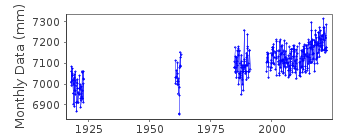
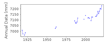
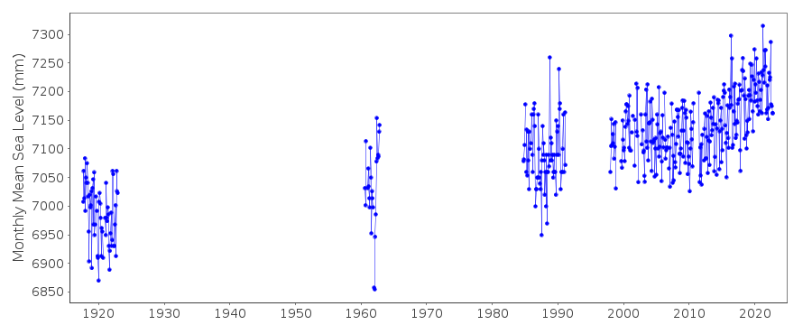
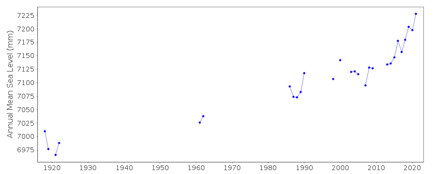
| Time span of data: | 1917 – 2022 |
| Completeness (%): | 33 |
| Date of last update: | 18 Sep 2023 |
| Green Arrow: | Current Station |
| Yellow Marker: | Neighbouring RLR Station |
| Red Marker: | Neighbouring Metric Station |
Please note: In many cases, the station position in our database is accurate to only one minute. Thus, the tide gauge may not appear to be on the coast.
Tide Gauge Data
Additional Data Sources (guide to additional data sources)
Nearby GNSS Stations from SONEL: BLUFFast Delivery Data from UHSLC station 72: hourly and daily
Research Quality Data from UHSLC station 72: hourly and daily
Station Documentation
Link to RLR information.Documentation added 1993-07-12
Bluff(Southland H) 690/041 RLR(1922) is 14.0m below Fundamental BMDocumentation added 2002-02-07
Bluff data now supplied by Land Information New Zealand (LINZ) (Auth=53). Previously supplied by Royal NZ Navy (Auth=A5).Documentation added 2003-01-17
New data from John Hannah added 17/01/03 which supercedes old data. New data does not have any missing days information. Old data has been backed up.Documentation added 2003-01-17
New data from John Hannah was for Auckland II, Dunedin II, Lyttelton II and Wellington II.Documentation added 2005-10-17
There is a new John Hannah paper referring to New Zealand data for Wellington, Dunedin, Lyttelton and Auckland. The reference is: "An updated analysis of long-term sea level change in New Zealand." Geophysical Research Letters, V31, L03307, doi:10.1029/2003GL019166 (2004).Documentation added 2008-10-01
Full dataset for Bluff 1982-2007 received from Glen Rowe at LINZ 01.10.08.Documentation added 2021-08-23
An updated version of the New Zealand data has been received from the data supplier Land Information New Zealand (LINZ) for station 213 the revised data starts from 2014 this exercise has been carried out to correct some issues within the high frequency data.Documentation added 2021-08-23
A revised copy of the New Zealand data values for station Bluff (Southland Harbour) has been received from the data supplier the Land Information New Zealand (LINZ). The revised dataset begins in 2014. This exercise has been carried out to correct some anomalies with the high frequency data.Data Authority
Land Information New Zealand155 The Terrace
PO 5501
Wellington 6145

![]()
![]()
![]()
