Data
- Obtaining
- Supplying
- High-Frequency
- Bottom Pressure Records
- Other Long Records
- GLOSS/ODINAFRICA Calibration Data
Donate
Donate to PSMSL
Data Notes
- Individual Station Data and Plot Notes
- Referencing the Data Set
- PSMSL Help File
- 2010 Changes to the PSMSL Data Files
Extracted from Database
11 Mar 2024
Station Information
| Station ID: | 209 |
| Latitude: | 36.527819 |
| Longitude: | -6.311412 |
| Coastline code: | 220 |
| Station code: | 2 |
| Country: | SPAIN |
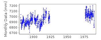
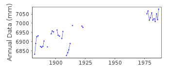
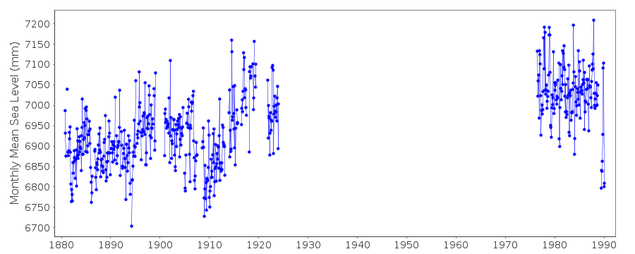
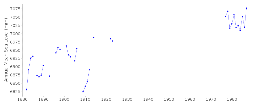
| Time span of data: | 1880 – 1990 |
| Completeness (%): | 42 |
| Date of last update: | 26 Jun 2013 |
| Green Arrow: | Current Station |
| Yellow Marker: | Neighbouring RLR Station |
| Red Marker: | Neighbouring Metric Station |
Please note: In many cases, the station position in our database is accurate to only one minute. Thus, the tide gauge may not appear to be on the coast.
Tide Gauge Data
Additional Data Sources (guide to additional data sources)
Nearby GNSS Stations from SONEL: SFER, ROAG, ROAPStation Documentation
Link to RLR information.Documentation added 1991-06-11
Cadiz II 220/002 RLR(1977) is 11.2m below BM NAPA-724Documentation added 1993-12-14
Gauge out of order since 1990Cadiz II is an historic station last data 1988
Data Authority
Instituto Geográfico NacionalRed de Infraestructuras Geodésicas
General Ibáñez de Ibero, 3
28003, Madrid

![]()
![]()
![]()
