Data
- Obtaining
- Supplying
- High-Frequency
- Bottom Pressure Records
- Other Long Records
- GLOSS/ODINAFRICA Calibration Data
Donate
Donate to PSMSL
Data Notes
- Individual Station Data and Plot Notes
- Referencing the Data Set
- PSMSL Help File
- 2010 Changes to the PSMSL Data Files
Extracted from Database
11 Mar 2024
Station Information
| Station ID: | 206 |
| Latitude: | 11.683333 |
| Longitude: | 92.766667 |
| GLOSS ID: | 38 |
| Coastline code: | 540 |
| Station code: | 1 |
| Country: | INDIA |
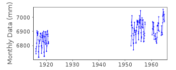
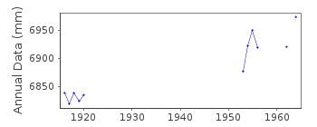
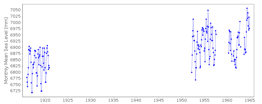
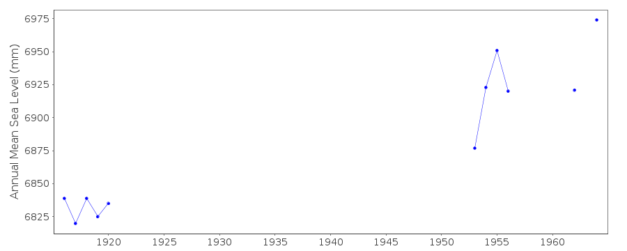
| Time span of RLR data: | 1916 – 1964 |
| RLR completeness (%): | 29 |
| Time span of metric data: | 1916 – 2020 |
| Metric completeness (%): | 23 |
| MTL Data: | 1952-1957 |
| MTL-MSL (mm): | 4 |
| Date of last update: | 31 Aug 2022 |
| Green Arrow: | Current Station |
| Yellow Marker: | Neighbouring RLR Station |
| Red Marker: | Neighbouring Metric Station |
Please note: In many cases, the station position in our database is accurate to only one minute. Thus, the tide gauge may not appear to be on the coast.
Tide Gauge Data
Additional Data Sources (guide to additional data sources)
Nearby GNSS Stations from SONEL: PBRI, CARI, PBR2Nearby Real Time Stations from VLIZ: ptbl
Fast Delivery Data from UHSLC station 908: hourly and daily
Station Documentation
Link to RLR information.Documentation - date unknown
1952-1957 Values based on readings of high and low watersDocumentation added 1991-06-11
Port Blair 540/001 RLR(1964) is 11.0m below BM 1EDocumentation added 2010-09-15
Port Blair was switched to 'Metric' following receipt of the data for 2002 there seems to be anomaly between the information supplied with the data i.e. benchmark name and details to what the data looks like when plotted. Benchmark 1992 Type B 4.39m above Chart Datum and BM No.1E 5.30m above Chart Datum are mentioned in a letter dated 05.07.07. For data 2002 the benchmark is quoted as being BM BOM 4.385m above Chart Datum - could this actually be BM 1992 Type B as previously? For data 2003 onwards benchmark is given as BM BOM 5.04m above Chart Datum although again the data 2006/7 is obviously to a different datum to 2003.Documentation added 2016-01-12
We have changed the first line above, indicating that the MTL ends in 1957, not 1956 as was previously stated. We have verified that the values in the database are those from Pub. Sci. 20, in which they were indicated as MTL.Documentation added 2016-01-22
A value of MTL-MSL=4 mm has been applied to the RLR data for the period 1952-1957. This value was derived from the average of two differences in the annual MSL and MTL listed in Pub. Sci. 24. Note that no correction has been applied to the metric data.Data Authority
Survey of IndiaGeodetic and Research Branch
17 E.C. Road
Dehra Dun
PIN 248 001

![]()
![]()
![]()
