Data
- Obtaining
- Supplying
- High-Frequency
- Bottom Pressure Records
- Other Long Records
- GLOSS/ODINAFRICA Calibration Data
Donate
Donate to PSMSL
Data Notes
- Individual Station Data and Plot Notes
- Referencing the Data Set
- PSMSL Help File
- 2010 Changes to the PSMSL Data Files
Extracted from Database
11 Mar 2024
Station Information
| Station ID: | 194 |
| Latitude: | 63.708567 |
| Longitude: | 22.689583 |
| Coastline code: | 60 |
| Station code: | 41 |
| Country: | FINLAND |
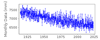
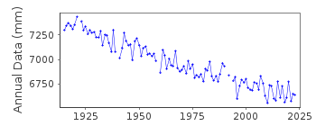
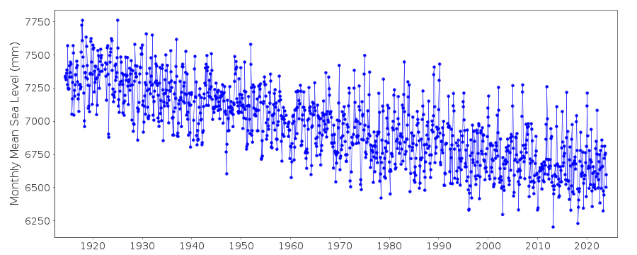
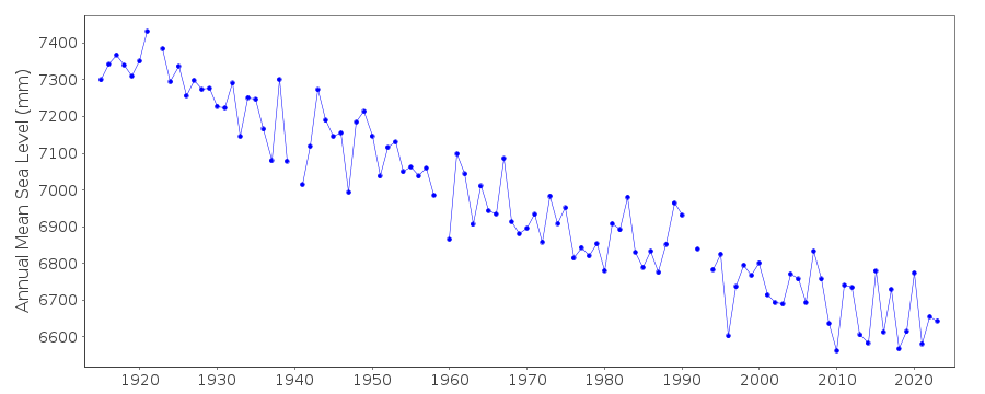
| Time span of data: | 1914 – 2023 |
| Completeness (%): | 98 |
| Date of last update: | 05 Mar 2024 |
| Green Arrow: | Current Station |
| Yellow Marker: | Neighbouring RLR Station |
| Red Marker: | Neighbouring Metric Station |
Please note: In many cases, the station position in our database is accurate to only one minute. Thus, the tide gauge may not appear to be on the coast.
Tide Gauge Data
Station Documentation
Link to RLR information.Documentation added 1991-06-11
Piertarsaari/Jakob 060/041 RLR(1964) is 8.7m below BM1196EDocumentation added 2002-09-24
A description of the sea level network in Finland can be found in 'Operational Oceanography: Implementation at the European and Regional scales. 2002 (pp.129-137)'.1914-1921 Values based on 1 reading per day
1922-1970 Values based on 6 readings per day
Documentation added 2012-01-09
Levelling information recently supplied by the Finnish Meteorological Institute confirms previous benchmark 1196E is no longer in use. Benchmark 1196G is 5.689m above gauge datum and benchmark 10401 4.015m above gauge datum was added in 2010.Documentation added 2017-01-31
In the 2016 yearly levelling of the Finnish tide gauges by the National Land Survey of Finland it was found that the benchmark 10401 was sinking by approximately 0.5mm per year. As a result this benchmark will not now be used but be replaced by the bed rock benchmark 1196G. These findings caused a correction of -3mm to the data for June 2013 onwards and 2014 data. The data values have been adjusted for this. Primary benchmark is now 1196G. The RLR diagram has been re-drawn.Documentation added 2019-11-27
From 2018 onwards the averages of the Finnish sea level data will be based on 1 min observations. Values are calculated in Finnish normal time (EET).The data are relative to the reference surface of the Finnish sea level observations and thus the datum is the tide gauge zero.
Data Authority
Finnish Meteorological InstituteMarine Research, Waves and Sea Level
Erik Palenin aukio 1
P.O. Box 503
FI - 00101 Helsinki

![]()
![]()
![]()
