Data
- Obtaining
- Supplying
- High-Frequency
- Bottom Pressure Records
- Other Long Records
- GLOSS/ODINAFRICA Calibration Data
Donate
Donate to PSMSL
Data Notes
- Individual Station Data and Plot Notes
- Referencing the Data Set
- PSMSL Help File
- 2010 Changes to the PSMSL Data Files
Extracted from Database
11 Mar 2024
Station Information
| Station ID: | 1938 |
| Latitude: | 37.979556 |
| Longitude: | 23.534194 |
| Coastline code: | 290 |
| Station code: | 29 |
| Country: | GREECE |
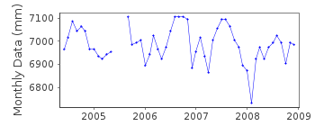
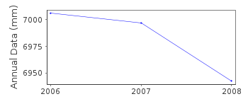
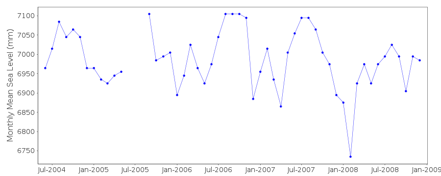
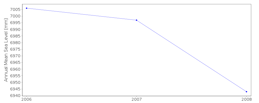
| Time span of data: | 2004 – 2008 |
| Completeness (%): | 87 |
| Date of last update: | 12 Aug 2013 |
| Green Arrow: | Current Station |
| Yellow Marker: | Neighbouring RLR Station |
| Red Marker: | Neighbouring Metric Station |
Please note: In many cases, the station position in our database is accurate to only one minute. Thus, the tide gauge may not appear to be on the coast.
Tide Gauge Data
Additional Data Sources (guide to additional data sources)
Nearby Real Time Stations from VLIZ: peirStation Documentation
Link to RLR information.Documentation added 2008-04-02
Original gauge ceased operating at the end of 2000. Gauge was re-instated at Lat.37 59N Long.23 32E in 2004. Although one of the original benchmarks was retained it was decided to treat it as a new station NORTH SALAMINOS II. From information received the Primary benchmark was taken to be R 20Data Authority
Hellenic Navy Hydrographic ServiceGeographic Policy and International Relations Office
TGN 1040
Athens

![]()
![]()
![]()
