Data
- Obtaining
- Supplying
- High-Frequency
- Bottom Pressure Records
- Other Long Records
- GLOSS/ODINAFRICA Calibration Data
Donate
Donate to PSMSL
Data Notes
- Individual Station Data and Plot Notes
- Referencing the Data Set
- PSMSL Help File
- 2010 Changes to the PSMSL Data Files
Extracted from Database
11 Mar 2024
Station Information
| Station ID: | 1893 |
| Latitude: | 1.582778 |
| Longitude: | 110.422222 |
| Coastline code: | 663 |
| Station code: | 21 |
| Country: | MALAYSIA |
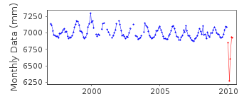
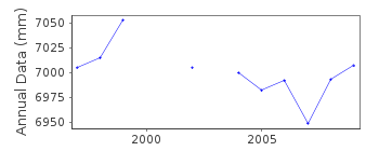
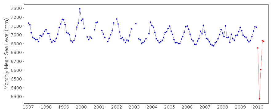
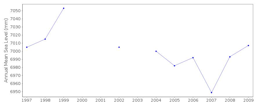
| Time span of data: | 1997 – 2010 |
| Completeness (%): | 90 |
| Date of last update: | 25 Jul 2011 |
| Green Arrow: | Current Station |
| Yellow Marker: | Neighbouring RLR Station |
| Red Marker: | Neighbouring Metric Station |
Please note: In many cases, the station position in our database is accurate to only one minute. Thus, the tide gauge may not appear to be on the coast.
Tide Gauge Data
Station Documentation
Link to RLR information.Documentation added 2001-02-23
Sejingkat 663/021 RLR(1997) is 10.3m below BM no. 10001Documentation added 2012-09-19
Publication Tidal Observation Records 2010 confirms that the Primary benchmarkremains BM No. 10001 8.983m above TGZ.
Documentation added 2012-11-21
There is no monthly mean data for Sejingkat 2011 as the data contains manyerrors.
Data Authority
Department of Survey and MappingWisma JUPEM
Jalan Semarak
50578 Kuala Lumpur

![]()
![]()
![]()
