Data
- Obtaining
- Supplying
- High-Frequency
- Bottom Pressure Records
- Other Long Records
- GLOSS/ODINAFRICA Calibration Data
Donate
Donate to PSMSL
Data Notes
- Individual Station Data and Plot Notes
- Referencing the Data Set
- PSMSL Help File
- 2010 Changes to the PSMSL Data Files
Extracted from Database
11 Mar 2024
Station Information
| Station ID: | 1878 |
| Latitude: | 50.714333 |
| Longitude: | -1.874861 |
| Coastline code: | 170 |
| Station code: | 146 |
| Country: | UNITED KINGDOM |
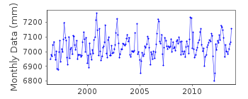
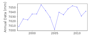
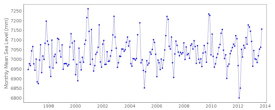
| Time span of data: | 1996 – 2013 |
| Completeness (%): | 96 |
| Date of last update: | 02 Jul 2014 |
| Green Arrow: | Current Station |
| Yellow Marker: | Neighbouring RLR Station |
| Red Marker: | Neighbouring Metric Station |
Please note: In many cases, the station position in our database is accurate to only one minute. Thus, the tide gauge may not appear to be on the coast.
Tide Gauge Data
Additional Data Sources (guide to additional data sources)
Nearby GNSS Stations from SONEL: POOLNearby Real Time Stations from VLIZ: bour
Station Documentation
Link to RLR information.Documentation added 2000-04-25
Bournemouth 170/146 RLR(1997) is 11.4m below BM Aux 1Documentation added 2001-01-02
Recent work on vertical land movements in the UK can be found fromthe University of Nottingham web site:
http://ukcogr.iessg.nottingham.ac.uk/~eosi/
Documentation added 2014-07-02
The steelwork at the gauge was damaged in a storm on 29.10.13. The refurbishment is awaiting divers to survey the damage and measure for new steelwork.Documentation added 2015-05-06
There is no data for Bournemouth during 2014. However TGI were at site 28.07.14 for levelling and establishing a benchmark on the pier. A Vega radar gauge was installed on 03.09.14. TGI were also at site 05.11.14 problems are likely to remain until January 2015.Data Authority
Horizon HouseDeanery Road
BS1 5AH
Bristol

![]()
![]()
![]()
