Data
- Obtaining
- Supplying
- High-Frequency
- Bottom Pressure Records
- Other Long Records
- GLOSS/ODINAFRICA Calibration Data
Donate
Donate to PSMSL
Data Notes
- Individual Station Data and Plot Notes
- Referencing the Data Set
- PSMSL Help File
- 2010 Changes to the PSMSL Data Files
Extracted from Database
11 Mar 2024
Station Information
| Station ID: | 1858 |
| Latitude: | 25.73 |
| Longitude: | -80.161667 |
| GLOSS ID: | 332 |
| Coastline code: | 960 |
| Station code: | 8 |
| Country: | UNITED STATES |
| Time span of data: | 1994 – 2023 |
| Completeness (%): | 99 |
| Link to ellipsoid: | Available |
| Date of last update: | 10 Jan 2024 |
| Green Arrow: | Current Station |
| Yellow Marker: | Neighbouring RLR Station |
| Red Marker: | Neighbouring Metric Station |
Please note: In many cases, the station position in our database is accurate to only one minute. Thus, the tide gauge may not appear to be on the coast.
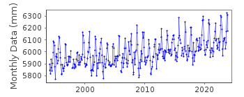
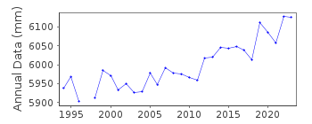
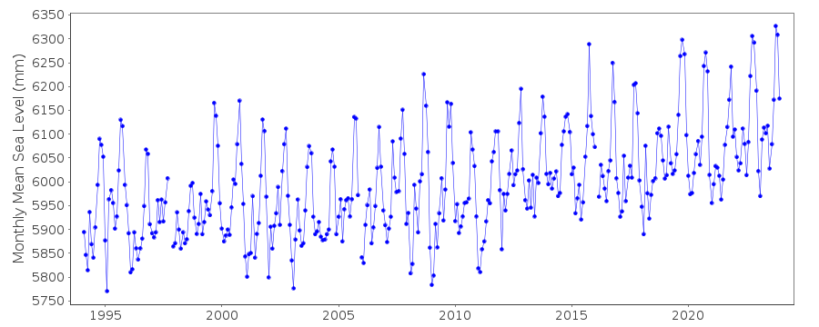
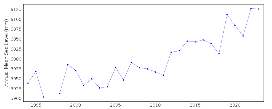
Tide Gauge Data
Additional Data Sources (guide to additional data sources)
Nearby GNSS Stations from SONEL: SA20, N300, MIA3, AOMLFast Delivery Data from UHSLC station 755: hourly and daily
Research Quality Data from UHSLC station 755: hourly and daily
Station Documentation
Link to RLR information.Documentation added 2000-04-26
Virginia Key 960/008 RLR(1999) is 7.605m below BM 3214 1994Documentation added 2012-02-23
From the NOAA website Primary benchmark is now 3214 B 1994 5.000m above TGZ.Data Authority
N.O.A.A. / N.O.S.N/oes33, Ssmc4, Room 6531
1305 East-West Highway
Silver Spring,
MD 20910

![]()
![]()
![]()
