Data
- Obtaining
- Supplying
- High-Frequency
- Bottom Pressure Records
- Other Long Records
- GLOSS/ODINAFRICA Calibration Data
Donate
Donate to PSMSL
Data Notes
- Individual Station Data and Plot Notes
- Referencing the Data Set
- PSMSL Help File
- 2010 Changes to the PSMSL Data Files
Extracted from Database
11 Mar 2024
Station Information
| Station ID: | 1838 |
| Latitude: | 7.106028 |
| Longitude: | 171.372806 |
| GLOSS ID: | 112 |
| Coastline code: | 720 |
| Station code: | 17 |
| Country: | MARSHALL ISLANDS |
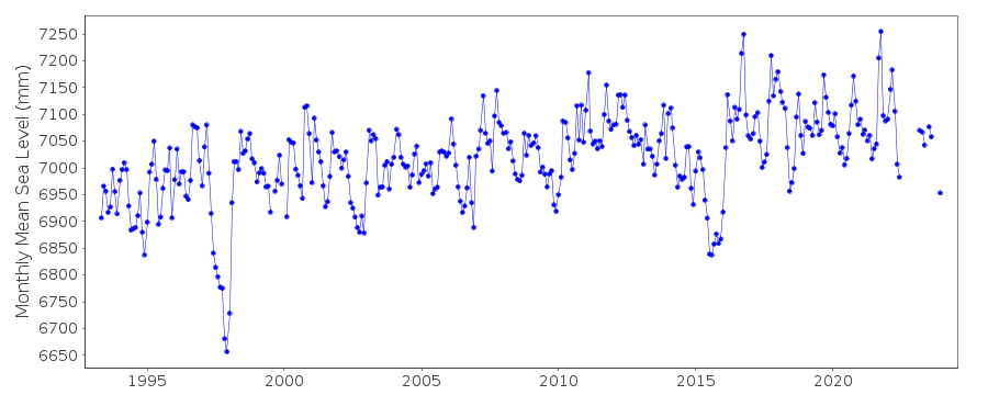
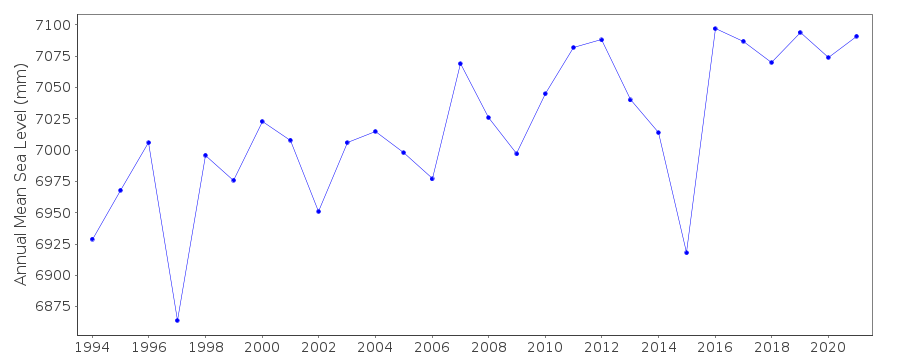
| Time span of data: | 1993 – 2023 |
| Completeness (%): | 95 |
| Link to ellipsoid: | Available |
| Date of last update: | 05 Feb 2024 |
| Green Arrow: | Current Station |
| Yellow Marker: | Neighbouring RLR Station |
| Red Marker: | Neighbouring Metric Station |
Please note: In many cases, the station position in our database is accurate to only one minute. Thus, the tide gauge may not appear to be on the coast.
Tide Gauge Data
Additional Data Sources (guide to additional data sources)
Nearby GNSS Stations from SONEL: MAJUNearby Real Time Stations from VLIZ: marsh
Fast Delivery Data from UHSLC station 5: hourly and daily
Research Quality Data from UHSLC station 5: hourly and daily
Station Documentation
Link to RLR information.Documentation added 1998-01-13
National Tidal Facility SEAFRAME stationDocumentation added 2010-08-26
Data supplier has confirmed that tide gauge zero for all data is LAT (93-94)Tide gauge benchmark MAR 3 is 2.659 m above LAT.RLR (2009) is defined as 8.6 m below MAR 3Documentation added 2019-01-23
A number of data values prior to 2010 have been revised. Because of this the entire data series has been re-loaded.Data Authority
National Tidal CentreBureau of Meteorology
PO Box 421
Kent Town 5071
South Australia
Documentation added 2010-08-12
Formerly known as the National Tidal Facility

![]()
![]()
![]()
