Data
- Obtaining
- Supplying
- High-Frequency
- Bottom Pressure Records
- Other Long Records
- GLOSS/ODINAFRICA Calibration Data
Donate
Donate to PSMSL
Data Notes
- Individual Station Data and Plot Notes
- Referencing the Data Set
- PSMSL Help File
- 2010 Changes to the PSMSL Data Files
Extracted from Database
11 Mar 2024
Station Information
| Station ID: | 1835 |
| Latitude: | 29.728333 |
| Longitude: | -93.87 |
| Coastline code: | 940 |
| Station code: | 10 |
| Country: | UNITED STATES |
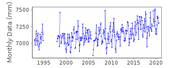
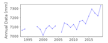
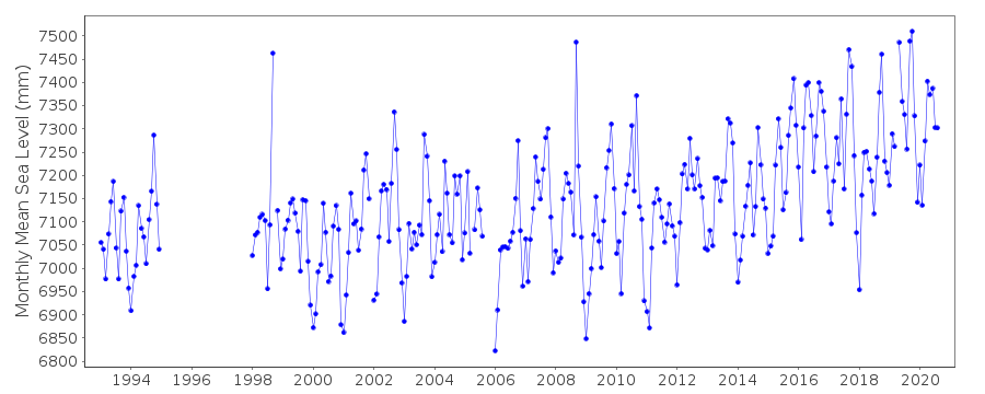
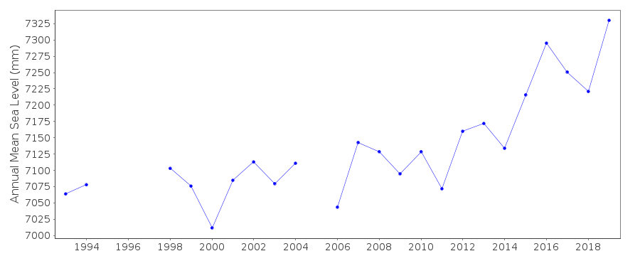
| Time span of data: | 1993 – 2020 |
| Completeness (%): | 86 |
| Date of last update: | 02 Feb 2021 |
| Green Arrow: | Current Station |
| Yellow Marker: | Neighbouring RLR Station |
| Red Marker: | Neighbouring Metric Station |
Please note: In many cases, the station position in our database is accurate to only one minute. Thus, the tide gauge may not appear to be on the coast.
Tide Gauge Data
Additional Data Sources (guide to additional data sources)
Research Quality Data from UHSLC station 766: hourly and dailyStation Documentation
Link to RLR information.Documentation added 1993-07-29
Many stations on the Gulf coast have large values for September 1961.Documentation added 2011-06-23
October-December 2009 values replaced to bring PSMSL record in line with NOAA website, which was updated to account for ongoing issues related to Hurricane Ike in September 2008Documentation added 2013-02-19
Sabine Pass North has been made a RLR station. Primary Benchmark is 0570 A 1985 3.264m above TGZ. RLR factor is 5.736mData Authority
N.O.A.A. / N.O.S.N/oes33, Ssmc4, Room 6531
1305 East-West Highway
Silver Spring,
MD 20910

![]()
![]()
![]()
