Data
- Obtaining
- Supplying
- High-Frequency
- Bottom Pressure Records
- Other Long Records
- GLOSS/ODINAFRICA Calibration Data
Donate
Donate to PSMSL
Data Notes
- Individual Station Data and Plot Notes
- Referencing the Data Set
- PSMSL Help File
- 2010 Changes to the PSMSL Data Files
Extracted from Database
11 Mar 2024
Station Information
| Station ID: | 1394 |
| Latitude: | 37.995 |
| Longitude: | -122.976667 |
| Coastline code: | 823 |
| Station code: | 30 |
| Country: | UNITED STATES |
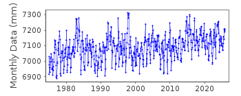
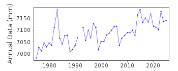
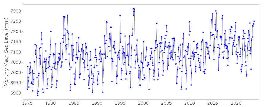
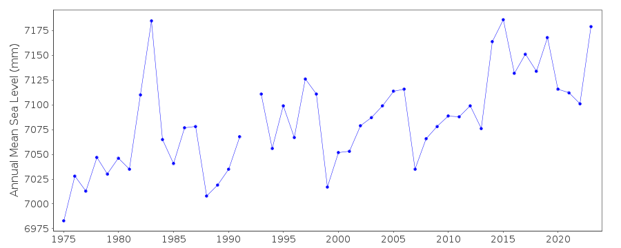
| Time span of data: | 1975 – 2023 |
| Completeness (%): | 99 |
| Date of last update: | 10 Jan 2024 |
| Green Arrow: | Current Station |
| Yellow Marker: | Neighbouring RLR Station |
| Red Marker: | Neighbouring Metric Station |
Please note: In many cases, the station position in our database is accurate to only one minute. Thus, the tide gauge may not appear to be on the coast.
Tide Gauge Data
Station Documentation
Link to RLR information.Documentation added 1991-06-11
Point Reyes 823/030 RLR(1981) is 9.9m below BM B243 1949Documentation added 2011-12-20
Using NOAA data the RLR diagram has been reviewed. Primary benchmark remains B 243 1949 4.977m above gauge datum.Documentation added 2012-09-18
For information: Data values during the early 1980's appear to be particularly high. This phenomenon could be due to the El Nino Southern Oscillation (ENSO)as it is mirrored all along the Californian coast.Data Authority
N.O.A.A. / N.O.S.N/oes33, Ssmc4, Room 6531
1305 East-West Highway
Silver Spring,
MD 20910

![]()
![]()
![]()
