Data
- Obtaining
- Supplying
- High-Frequency
- Bottom Pressure Records
- Other Long Records
- GLOSS/ODINAFRICA Calibration Data
Donate
Donate to PSMSL
Data Notes
- Individual Station Data and Plot Notes
- Referencing the Data Set
- PSMSL Help File
- 2010 Changes to the PSMSL Data Files
Extracted from Database
11 Mar 2024
Station Information
| Station ID: | 137 |
| Latitude: | 46.266667 |
| Longitude: | -72.616667 |
| Coastline code: | 970 |
| Station code: | 76 |
| Country: | CANADA |
| Time span of RLR data: | 1961 – 2022 |
| RLR completeness (%): | 72 |
| Time span of metric data: | 1900 – 2022 |
| Metric completeness (%): | 38 |
| Date of last update: | 16 Feb 2024 |
| Green Arrow: | Current Station |
| Yellow Marker: | Neighbouring RLR Station |
| Red Marker: | Neighbouring Metric Station |
Please note: In many cases, the station position in our database is accurate to only one minute. Thus, the tide gauge may not appear to be on the coast.
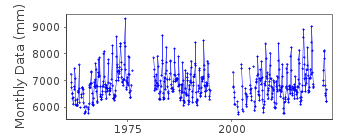
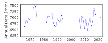
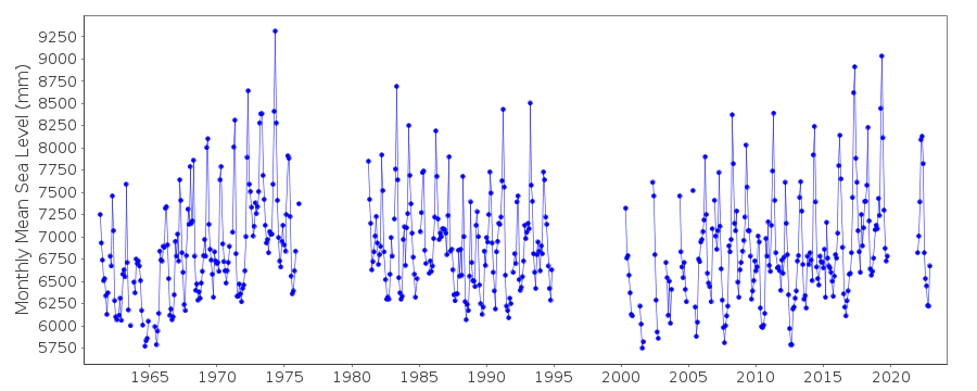
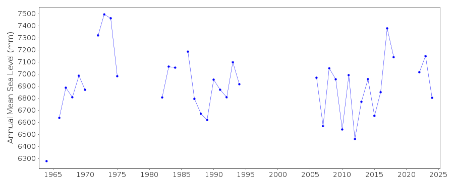
Tide Gauge Data
Station Documentation
Link to RLR information.Documentation added 1994-03-23
Data up to 1992 revised, March 1994Documentation added 2013-05-09
Port Saint Francois has now been made RLR. Datum up to 2008 is UGLD85 and from 2009 onwards is Chart Datum. Full dataset to Chart Datum including the relationship between IGLD85 and Chart Datum. were supplied but to 2 decimal places only. Using the relationship between the two datums the rlrfactor was used to correct the complete dataset. Benchmark POSF1-60 is 4.268m above Chart Datum.Documentation added 2015-07-27
This year, rather than just sending the latest year of data, the complete dataset has been supplied. This has highlighted some differences in the data. From communications in the correspondence file for 2002 it appears that the Oceans and Fisheries meant to supply revised data for the stations supplied. This did not happen. The complete dataset includes these data revisions. Therefore, the whole dataset has now been re-entered.Documentation added 2015-07-30
Historic data was included in the above complete dataset. The datum for the period 1900-1903 is currently being queried. Until the Fisheries and Oceans Canada confirm the datum this data has been made Metric.Documentation added 2016-06-28
It has now been confirmed from the Canadian Authority that the historic data for 1900-1903 should be ignored as there is no supporting metadata for these data.Data Authority
Canadian Hydrographic Service615 Booth Street
Ottawa
Ontario K1A 0E6

![]()
![]()
![]()
