Data
- Obtaining
- Supplying
- High-Frequency
- Bottom Pressure Records
- Other Long Records
- GLOSS/ODINAFRICA Calibration Data
Donate
Donate to PSMSL
Data Notes
- Individual Station Data and Plot Notes
- Referencing the Data Set
- PSMSL Help File
- 2010 Changes to the PSMSL Data Files
Extracted from Database
11 Mar 2024
Station Information
| Station ID: | 1329 |
| Latitude: | -2.816667 |
| Longitude: | -171.716667 |
| GLOSS ID: | 145 |
| Coastline code: | 750 |
| Station code: | 12 |
| Country: | KIRIBATI |
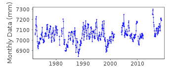
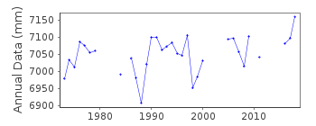
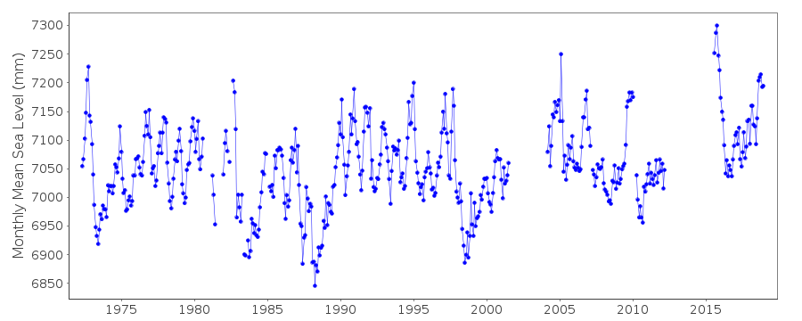
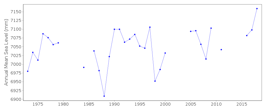
| Time span of data: | 1972 – 2018 |
| Completeness (%): | 83 |
| Date of last update: | 28 Jan 2020 |
| Green Arrow: | Current Station |
| Yellow Marker: | Neighbouring RLR Station |
| Red Marker: | Neighbouring Metric Station |
Please note: In many cases, the station position in our database is accurate to only one minute. Thus, the tide gauge may not appear to be on the coast.
Tide Gauge Data
Additional Data Sources (guide to additional data sources)
Nearby Real Time Stations from VLIZ: kantFast Delivery Data from UHSLC station 13: hourly and daily
Research Quality Data from UHSLC station 13: hourly and daily
Station Documentation
Link to RLR information.Documentation added 1991-06-11
Kanton Island II 750/012 RLR(1986) is 9.0m below BMUH-1Documentation added 1996-10-07
gauge type: (Feb 1975 - Feb 1986 )Fischer and Porter Analog-to-Digital Recorder (ADR); (Feb 1986-present) Leupold and Stevens Analog-to-Digital Recorder (ADR); (Feb 1982-present) Handar Encoder (ENC) *note, for May 1972 - Feb 1975, type unconfirmed Primary gauge: ADR: 1975-90, ENC: 1991-Documentation added 2010-11-17
The complete dataset 1972-2007 supplied by UHSLC. After checking these with existing data values these have been loaded onto the database.RLR value remains 6.013m.Documentation added 2013-10-14
Complete dataset May 1972 to April 2012 downloaded onto database from UHSLCDocumentation added 2015-09-23
From information extracted from the UH levelling sheets it appears that the RLR diagram was drawn using the values from the 1977 levelling. In subsequent levelling exercises the Primary Benchmark on the diagram UH1 is not stable. UH now appear to be using the tide staff value of 2.604m relative to the datum.Data Authority
University of HawaiiDepartment of Oceanography Division of Natural Sciences
1000 Pope Road
Honolulu
Hawaii 96822

![]()
![]()
![]()
