Data
- Obtaining
- Supplying
- High-Frequency
- Bottom Pressure Records
- Other Long Records
- GLOSS/ODINAFRICA Calibration Data
Donate
Donate to PSMSL
Data Notes
- Individual Station Data and Plot Notes
- Referencing the Data Set
- PSMSL Help File
- 2010 Changes to the PSMSL Data Files
Extracted from Database
11 Mar 2024
Station Information
| Station ID: | 1327 |
| Latitude: | -18.135678 |
| Longitude: | 178.422839 |
| GLOSS ID: | 122 |
| Coastline code: | 742 |
| Station code: | 12 |
| Country: | FIJI |
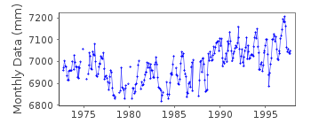
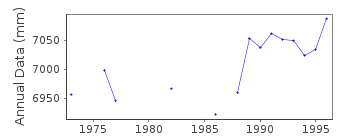
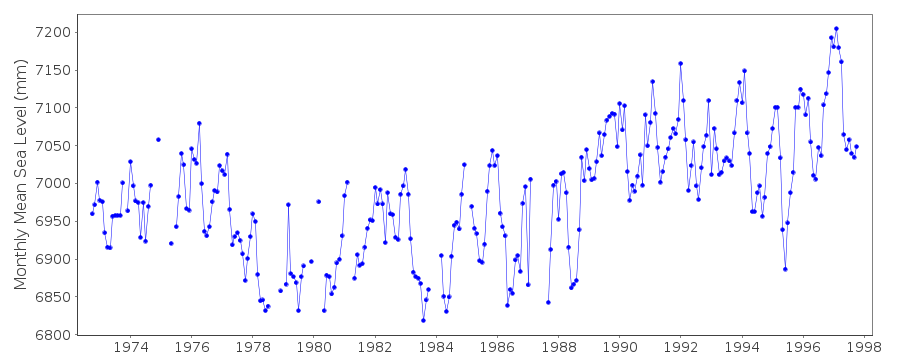
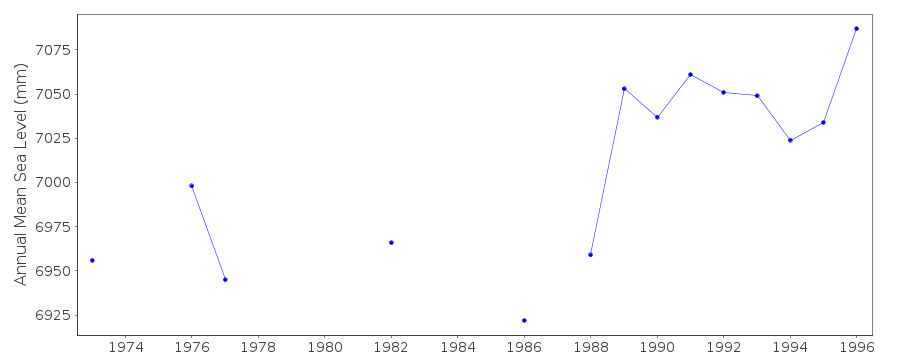
| Time span of data: | 1972 – 1997 |
| Completeness (%): | 86 |
| Date of last update: | 19 Aug 2010 |
| Green Arrow: | Current Station |
| Yellow Marker: | Neighbouring RLR Station |
| Red Marker: | Neighbouring Metric Station |
Please note: In many cases, the station position in our database is accurate to only one minute. Thus, the tide gauge may not appear to be on the coast.
Tide Gauge Data
Additional Data Sources (guide to additional data sources)
Nearby GNSS Stations from SONEL: SUVA, USP1Nearby Real Time Stations from VLIZ: viti
Fast Delivery Data from UHSLC station 18: hourly and daily
Research Quality Data from UHSLC station 18: hourly and daily
Station Documentation
Link to RLR information.Documentation added 1995-09-28
Data 1975-1991 received from Toga officeDocumentation added 1995-09-28
1975-5/1989:Fischer and Porter Analog-to-Digital Recorder 6/1989-1990: Leupold and Stevens ADR gauge Aquatrak acoustic gauge, NOAA Next Generation Water Level Measuring System (NGWLMS) (1991-)March 1989: site moved from 18 07.9S 178 25.6E to 18 08.2S 178 25.6EDocumentation added 2000-04-10
For Information: A gauge was maintained on behalf of the TOGA Sea Level Center until it was withdrawn in May 1989. A gauge at Kings Wharf was destroyed in November 1983 and was re-located to Walu Bay Naval Facility (operated by University of Hawaii)There was a 3 month overlap between the new NOAA gauge and the Walu gauge.From November 1997 the responsibility for the station in Suva was taken over by the Australian National Tidal Facility from the US NOAA. Comparison of daily means for Suva with those for Lautoka and satellite altimetry suggest there could be land subsidence at the Suva station equating to a slow positive sea level trend.
Documentation added 2011-03-15
From the VLIZ site in Ostende a tsunami is visible 29-30 September 2009.Data Authority
University of HawaiiDepartment of Oceanography Division of Natural Sciences
1000 Pope Road
Honolulu
Hawaii 96822

![]()
![]()
![]()
