Data
- Obtaining
- Supplying
- High-Frequency
- Bottom Pressure Records
- Other Long Records
- GLOSS/ODINAFRICA Calibration Data
Donate
Donate to PSMSL
Data Notes
- Individual Station Data and Plot Notes
- Referencing the Data Set
- PSMSL Help File
- 2010 Changes to the PSMSL Data Files
Extracted from Database
11 Mar 2024
Station Information
| Station ID: | 1272 |
| Latitude: | -27.154722 |
| Longitude: | -109.472778 |
| GLOSS ID: | 137 |
| Coastline code: | 810 |
| Station code: | 3 |
| Country: | CHILE |
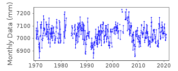
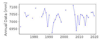
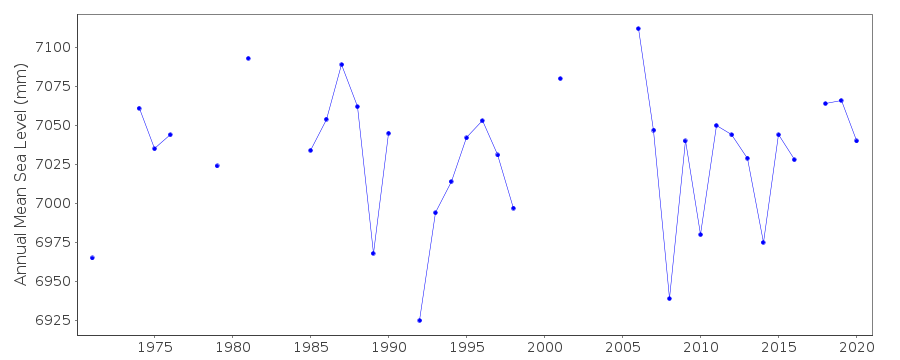
| Time span of data: | 1970 – 2020 |
| Completeness (%): | 83 |
| Date of last update: | 07 Apr 2021 |
| Green Arrow: | Current Station |
| Yellow Marker: | Neighbouring RLR Station |
| Red Marker: | Neighbouring Metric Station |
Please note: In many cases, the station position in our database is accurate to only one minute. Thus, the tide gauge may not appear to be on the coast.
Tide Gauge Data
Additional Data Sources (guide to additional data sources)
Nearby GNSS Stations from SONEL: EISL, ISPANearby Real Time Stations from VLIZ: east2, east
Fast Delivery Data from UHSLC station 22: hourly and daily
Research Quality Data from UHSLC station 22: hourly and daily
Station Documentation
Link to RLR information.Documentation added 1993-03-31
Data received from TOGA officeDocumentation added 1996-02-09
The period after the long gap in 1991 appears to have a lower mean level although data received via satellite also show this feature. It is not clear if a reference shift occurred during the gap.Documentation added 1996-06-17
Data 1994-95 received directly from Servicio de la Armada de ChileDocumentation added 1997-11-14
1996 data received from University of Hawaii Sea Level CentreDocumentation added 1997-11-14
Instrument type: Bristol bubbler gauge (BUB) (primary gauge 1985-01/1994)NOAA "digibub" water level gauge (PRS) (primary gauge 03/1994+)note: this gauge uses a nitrogen-driven bubbler oriface below the water line connected to a Para-scientific pressure transducer located at the DCP housing.The pressure transducers are vented to the atmosphere so no atmospheric corrections are required. NOAA backup pressure water level gauge (BWL)Documentation added 1997-12-09
1994-95 data revised with data received from the UHSLCDocumentation added 1998-12-15
1997 data received from the University of Hawaii Sea Level CenterDocumentation added 2004-10-20
Data for the period 1985-98 were replaced by a new data set received from the supplying authority (SHOA)Data Authority
Hydrographic and Oceanographic Service of the Chilean NavyErrazuriz 254
Playa Ancha
Valparaiso

![]()
![]()
![]()
