Data
- Obtaining
- Supplying
- High-Frequency
- Bottom Pressure Records
- Other Long Records
- GLOSS/ODINAFRICA Calibration Data
Donate
Donate to PSMSL
Data Notes
- Individual Station Data and Plot Notes
- Referencing the Data Set
- PSMSL Help File
- 2010 Changes to the PSMSL Data Files
Extracted from Database
11 Mar 2024
WARNING: QCFLAG EXISTS. PLEASE READ THE DOCUMENTATION.
Station Information
| Station ID: | 1251 |
| Latitude: | 9.516667 |
| Longitude: | 138.133333 |
| GLOSS ID: | 119 |
| Coastline code: | 710 |
| Station code: | 11 |
| Country: | MICRONESIA, FEDERATED STATES OF |
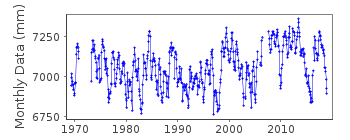
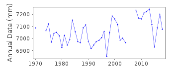
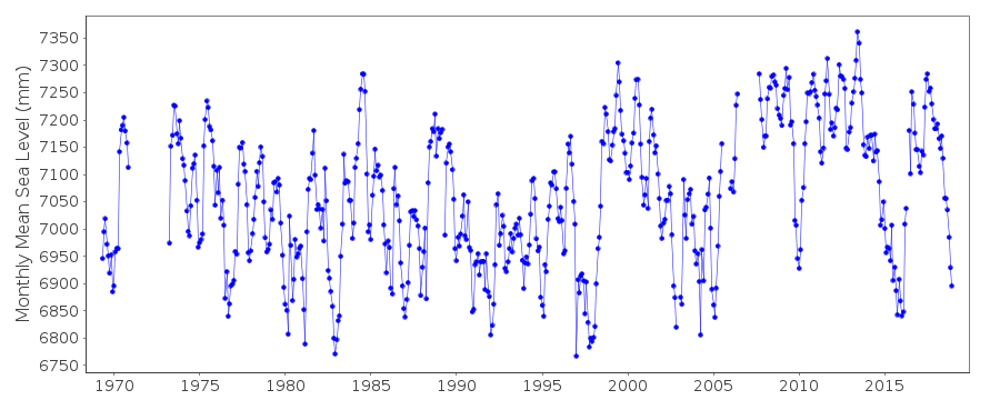
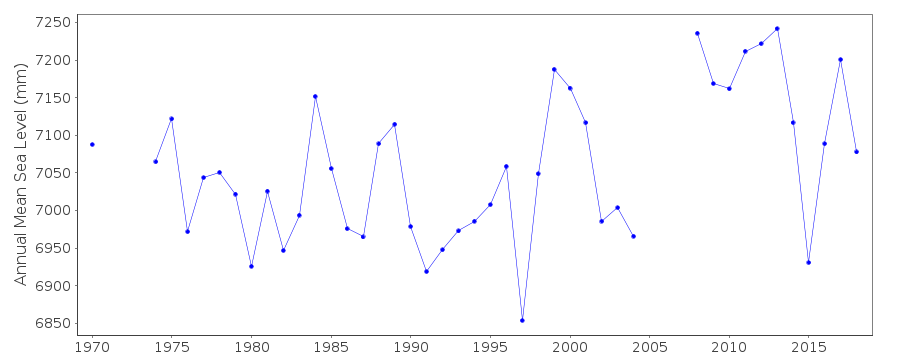
| Time span of data: | 1969 – 2018 |
| Completeness (%): | 91 |
| Date of last update: | 07 Mar 2023 |
| Green Arrow: | Current Station |
| Yellow Marker: | Neighbouring RLR Station |
| Red Marker: | Neighbouring Metric Station |
Please note: In many cases, the station position in our database is accurate to only one minute. Thus, the tide gauge may not appear to be on the coast.
Tide Gauge Data
Additional Data Sources (guide to additional data sources)
Nearby Real Time Stations from VLIZ: yapiFast Delivery Data from UHSLC station 8: hourly and daily
Research Quality Data from UHSLC station 8: hourly and daily
Station Documentation
Link to RLR information.Documentation added 1991-06-11
Yap 710/011 RLR(1983) is 19.1m below BM#5Documentation added 1992-10-27
Caution: The tide structure has a history of sinking. THhe tide staff bolted to the tide house has sunk about 3" between 1969-1973 and another 3" between 1973-1984.Documentation added 1996-10-07
Renamed YAP B on receipt of data "YAP A" instrument type: unconfirmed (1969-70); Bristol bubbler (1973-8/1974);Fischer and Porter Analog-to-Digital Recorder (ADR), (9/1974-);Handar Encoder (ENC), (5/1991-)Primary gauge: ADR:1974-4/91, ENC 5/91-Documentation added 1996-11-12
data 1969-70, 1973-94 and BM information revised in 1996 update from UHSLC. Consequently RLR redefined as RLR(1993): 10.0m below BM 7, 1990Documentation added 1997-11-13
1969-70 data contributed by Scripps Institution of Oceanography.Documentation added 1998-12-31
Data for 1994 revised in December 1998Documentation added 1999-11-15
Data for 1997 revised in December 1999Documentation added 2010-11-18
Data for 2005 has been received from UHSLC. These have now been entered into the database.Documentation added 2013-10-14
Complete dataset May 1969 to April 2012 was loaded onto the database from UHSLCDocumentation added 2015-10-28
Using the recently supplied JASL data up to the end of 2014 has been added to the database.Data Authority
University of HawaiiDepartment of Oceanography Division of Natural Sciences
1000 Pope Road
Honolulu
Hawaii 96822

![]()
![]()
![]()
